Anoka Riverfront Easement Rum Riverbank Stabilization

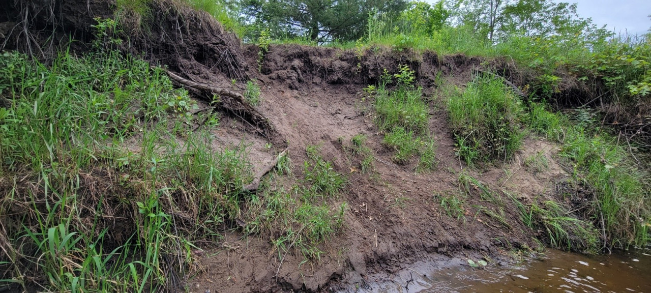
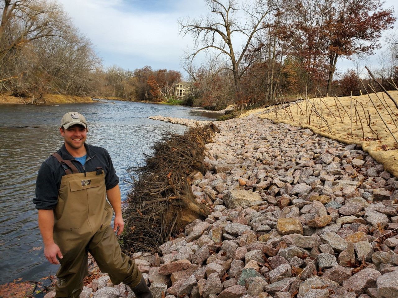
Erosion along 400-feet of Rum riverbank at a City of Anoka riverfront easement is causing sediment loading and tree loss, and has washed out a highly used walking trail. The design features three primary protection measures detailed below. 

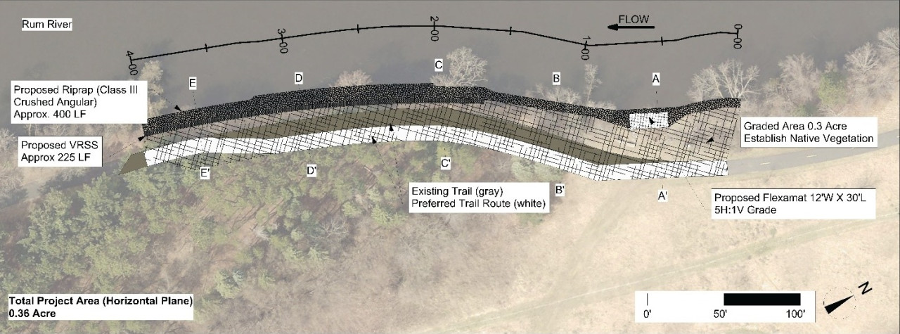
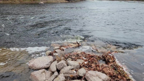
1. The toe of the bank, mostly below the water line, will be armored with a rock. The rock will be installed up to the two-year flood elevation (50% of years it will be completely covered). This lowers the top of the rock by two feet compared to the standard approach. This allows habitat friendly approaches above.

2. Above the rock, the bank will be seeded with a native plants, and staked with willow and dogwood. Native vegetation provides habitat benefit and root structure to anchor the soil in place. We may grade the bank back to a flatter, more stable slope. Alternatively, we may use a series of wrapped soil lifts called a "vegetated reinforced soil system" to maintain a steeper slope that is still stable and vegetated. The final decision will be based on bids received.

3. There is a heavily used informal access point at the upstream end of this site. This area gets beat down by heavy foot traffic. We will use one roll of articulated concrete block to offer stable footing and reduce the erosion caused by that foot traffic.

For more information contact Jared Wagner, Water Resource Specialist, at This email address is being protected from spambots. You need JavaScript enabled to view it.. 

  20 Hits

Working in the Rum River to Improve Habitat

A hallmark of ACD's natural resource work has included the stabilization of eroding riverbanks and the enhancement of native vegetation in adjacent riparian and floodplain areas. These activities improve water quality in the river and habitat quality along it. Included in the goals of our Phase 2 grant for Rum River habitat enhancement through the Outdoor Heritage Fund of the Clean Water Land and Legacy Amendment is the improvement of in-stream habitat in the Rum River channel. This is a new endeavor for ACD that presents an exciting opportunity to expand our work and our partnerships within the Rum River Corridor.

Though we are over a century removed from the widening and scouring of the Rum River by the millions of logs cut during the Minnesota timber boom, the effects of that industry still remain. Rivers used as log arteries were made wider and more consistent to ensure the smooth sailing of logs downstream. In more modern times, towns piped rain water directly to the river from impervious areas via stormwater conveyance systems. These rapid spikes in water input during storms exacerbate bank erosion, down-cutting, and sedimentation in the river at rates far beyond what was natural. 

The Washburn Saw Mill on the Rum River – late 1800s Source: Anoka County Historical Society
Plunging flow off the end of a bendway weir in the Rum River creating areas of rapid and slow flow, variable water levels, a scour pool, and quiet water depositional areas. This creates variability in flows and habitats.

Due to this historical usage of the Rum River as a conveyance tool for wood and stormwater, habitat for fish, invertebrates, mussels, and other aquatic life remains lacking and out of balance. In the coming years we will be partnering with Anoka County Parks, DNR Fisheries, The Nature Conservancy and others to identify and enhance missing or deficient in-stream habitat. Secondarily, we will look for enhancement opportunities for game fish habitat near publicly accessible shorelines to improve access to quality shore fishing. For more information contact Jared Wagner, Water Resource Specialist, at This email address is being protected from spambots. You need JavaScript enabled to view it.. 

  467 Hits

Project Update: Dellwood Park Stabilization

Construction is complete for a Rum Riverbank stabilization at Dellwood River Park in St. Francis. Erosion of the riverbank was resulting in the loss of numerous trees into the river and was threatening a popular local walking trail. The project design features three primary protection measures.

  1. Two severely eroding zones of riverbank were armored with rock riprap, and 14 large tree rootwads were added as in-stream habitat.
  2. Three rock bendway weirs were installed, protruding at 45° into the river. These low-lying features, will push flow and erosive scour back toward the middle of the channel, rather than along the outer bank.
  3. And finally, the less severely eroding areas of riverbank were armored with cedar trees in a bio-engineering technique called "cedar tree revetments".

In total, this project stabilizes 630 feet of riverbank, enhances 0.75 acres of in-stream and riparian habitat, and reduces annual loading into the river by 60 tons of sediment and 51lbs of phosphorus. The project also incorporates multiple features to enhance fishing opportunities and provide additional in-stream habitat. 

Previous Bank Conditions, 2022
Lead Staff, Jared Wagner, Post-Construction, November 2023

For more information contact Jared Wagner, Water Resource Specialist, This email address is being protected from spambots. You need JavaScript enabled to view it. 

  768 Hits

Dellwood River Park Shoreline Stabilization – Project Update

Construction is set to take place in October along 630-feet of eroding Rum Riverbank at Dellwood River Park in St. Francis. Erosion of the riverbank is causing numerous trees to fall into the river and is threatening a popular local walking trail. The project design features three primary protection measures;

  • 1)Two severely eroding zones of riverbank encroaching on the trail will be built back out, armored with rock riprap, and have large tree rootwads added as in-stream habitat elements. The riprapped length of bank will total approximately 180-feet in length. Large boulders will be strategically placed within the riprap to allow enhanced shore fishing opportunity.
  • 2)Three bendway weirs constructed of rock will protrude at 45° into the river. These low-lying, linear features will be submerged under the water (except during very low flows), and will push flow and erosive scour back toward the middle of the channel, rather than along the outer bank. They will also add variable flow areas and habitat value in the channel. These will be great features to cast around for any fisher folks from shore!
  • 3)And finally, the less severely eroding areas of riverbank will be armored with anchored cut cedar trees in a technique called a "cedar tree revetment". Cut eastern red cedars will be cabled together in a shingled fashion along the bank and secured with earth anchors driven into the soil. This is a softer armoring approach than rock which should help the bank stabilize, vegetate, and heal over time naturally before the cedar trees eventually rot away.

For more information contact Jared Wagner, Water Resource Specialist, This email address is being protected from spambots. You need JavaScript enabled to view it. 

  761 Hits

2023 Low Impact Development Conference

Rain Guardian Display Booth at the 2023 LID Conference

ACD recently exhibited at the 2023 Low Impact Development (LID) Conference held in Oklahoma City. The 2023 LID Conference had 250 registrants from 40 states. Jared Wagner, with the ACD office made the trip south, and had constructive interactions with folks working all across the country. Many organizations were already familiar with ACD's products but were interested for more information. Some groups did not know that ACD offers a variety of products that are designed to serve specific needs. The Foxhole product was particularly intriguing to folks in search of a solution for bioretention and pretreatment under sidewalks. The annual conference was well organized and a great way to meet and learn from professionals in other states who are dealing with the same types of environmental problems we face here in Minnesota.

For more information contact Jared Wagner, Water Resource Specialist, This email address is being protected from spambots. You need JavaScript enabled to view it. 

  700 Hits