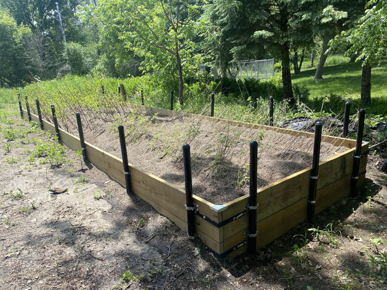
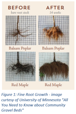
Get a Little Wild in Your Yard

I noticed my neighbors doing this in their backyard. At first, I thought it was odd and might attract unsavory characters to the neighborhood and bring down property values. Now, I'm a card carrying member of the Rewild Club. It's best to explain.

I took a hard look at my yard and ask myself…What do I want from this space?

  • A peaceful shady retreat?
  • Home grown food?
  • Entertainment central?
  • Ruckus area for kids and pets?

What do I need to make that happen? A patio, a water feature, play area, shade trees, garden plot, privacy screening, a lawn area for recreation, disco ball and dance floor, an amphitheater for Shakespeare in the Park night?

I realized that my yard was mostly seldom-used lawn and none of the other fun stuff.

Amphitheater and disco balls aside, I started to pull together a plan. The biggest surprise was how much better my yard would be if I did less work. I opted to rewild unused space. Along the perimeter of my yard I stopped mowing, I stopped raking, I stopped fertilizing, I stopped weeding, and I stopped watering. In other words, I released by inner teenager. I let trees and shrubs that popped up keep growing, and planted a few for fall color, nesting, fruit and flowers. In a few years, instead of staring at a fence that needed maintenance, I had a living screen of trees and shrubs. Birds and butterflies came back to enjoy the flowers and fruits of my lack of labor, and they turned out not to be the unsavory characters I had imagined. The shade makes hot summer days in the yard enjoyable and cuts my lawn watering in half. There still plenty of lawn for kids and pets, but now the space is a haven for the family and a little wildlife.

Tips for the would-be rewilder.

  1. Just mow less.
  2. Baby steps. Pick a small area to try first. Consider it a journey of many years, not a mountain to climb on a single trek.
  3. Forget tidy. Wild areas can be messy. You can keep the edges formal if you want.
  4. Pick up ID books for birds, flowers, and trees so you can get to know your new neighbors. Books? Did he say books? I think he meant App.
  5. Avoid using chemicals where the wild things are.
  6. Think vertically if you have a small space. Tall trees, medium sized trees, shrubs, wildflowers and grasses can call have a place in a very small area.
  7. Add a water feature to ramp up the wildlife appeal.
  8. Plant diversity is good. Variety will make the space more interesting and resistant to stressors like disease and drought.
  9. Speed up the process with affordable bare root trees and shrubs from your local conservation district annual tree sale.
  10. Avoid invaders. Learn a few of the invasive plants in your area and try to keep them out of your wild space.
  11. Let your neighbors know why you would do such zaniness.
  1406 Hits

District Capacity Funding Impact

Each year since 2016, soil and water conservation districts across the state, including ACD, have receiving a special allocation from the Clean Water Fund of the Clean Water, Land and Legacy Amendment to build statewide capacity to provide conservation related programs and services. Each district utilizes these funds differently to meet the needs of their constituents and natural resources. Following is a snapshot of how ACD relies on these funds.

District Capacity funds (DCF) have made the greatest difference in Anoka Conservation District (ACD) operations by serving as a highly adaptable funding source. We use DCF to tackle critical but small tasks that elevate our overall function and efficiency. Most individual projects and activities funded with DCF cost less than $5,000.

Education and Outreach: DCF has been used to create a natural resources Blog that is continually updated with timely content, a quarterly e-Newsletter that is distributed to key stakeholders and the public, and outreach materials including brochures, displays and animated videos; all of which are available at https://www.anokaswcd.org/educational.html.

Inventory: ACD completed riverbank and lakeshore condition photo inventories for our major rivers (Rum and Mississippi) and many lakes, totaling over 50 miles of shoreline. Photos are uploaded to Google maps where they are available by using the StreetView function for the public, and ACD staff when fielding calls from landowners.

Planning and Analysis: Streambank and lakeshore photos were analyzed to determine erosion location and severity, enabling ACD to identify and rank potential projects based on cost-effectiveness for water quality benefits. This was the foundation to secure many grants. Similar analysis of wetland restoration opportunities facilitates targeted outreach efforts.

Technical Capacity: Building staff expertise through training and technology upgrades, including design software and survey equipment.

Technical Assistance: In 2020, DCF was used to help complete 198 site consultations, 19 surveys and designs, and construction management for 20 projects for landowners. Technical assistance is a critical service to achieve conservation on private lands.

Cost Share: DCF is used to supplement other funding to help projects such as shoreline and riverbank stabilizations over the finish line.

Project Life Extension: Approximately 25 landowners annually are provided project management guidance to extend the benefits of their project beyond the contracted life. 

  1094 Hits

ACD Stands Poised for a Decade of Natural Resource Stewardship

ACD is pleased to present our 2021-2030 Comprehensive Natural Resource Stewardship Plan to our implementation partners and stakeholders. The plan embraces the fact that all natural resources are interconnected and interdependent and presents stewardship goals, objectives and strategies in a manner that will enhance our ability to address issues holistically. The plan is structured around four foundational natural resources: surface water, groundwater, ecological resources, and soils. We also dedicate a portion of the plan to our human resources in a section called Community.

While the plan has been adopted in its current state, over the coming four months ACD intends to reengage with stakeholders who helped bring the plan together to solicit additional input for incorporation into an amendment mid-2021.

Special purpose units of government like watershed districts and soil and water conservation districts routinely face the challenge of communicating progress toward goals amid the complexity of natural resources stewardship. Often this messaging is to stakeholders with limited expertise on the subject. To address this challenge, as a central component of the plan, ACD has developed an Action Wheel with 24 Keystone Endeavors across the four foundational natural resources, community and district operations. Annual success in achieving these endeavors will be reported in an easy to understand manner beginning with our 2021 Annual Report.

The extent to which ACD's efforts improve the quality of life of Anoka County residents is another matter. This delves into matters of ecosystem services, economics, spirituality, recreation, mental health, and so on. How to gauge the value of floating on a clean lake on a hot afternoon? We have a plan for this too, which will come together in our 2021 Annual Report.

Because ACD does not have statutory funding authority, budgets and work plans are aspirational as opposed to prescriptive. To project future budgets, expense and revenue trends over the prior ten years were used. The following revenue and expense projects may appear aggressive at first glance. Considering that Anoka County has over 350,000 residents and that two-thirds of projected revenues come from product sales and state grants, the burden on the Anoka County taxpayer to support ACD's work, including county and local government contributions, would be well below $5 per person. 

  1163 Hits

Comprehensive Planning Just Got More Comprehensive

Ten-year comprehensive plans are the foundation for many agency operations. We embarked on our planning process in the fall of 2018. It has been a long journey, with unexpected turns. Where we landed is not anything like I originally imagined. It is a product of the process, made better by the expertise and insight of many partners. While we may be situated in a landscape dominated by shifting sands, we are poised to have our operations solidly grounded in our 2021-2030 Comprehensive Plan.

Managing natural resources is a complicated endeavor. They are all interconnected. Changes to one resource cascade into changes in the others. As we set out on this journey, we grappled with how to compartmentalize natural resource management so we could structure a plan. Should it be by habitat type: lakes, river, wetlands, prairies, savannas, and forests; by land cover: agriculture, residential, commercial, open space; by what we value and use: drinking water, recreation, wildlife, food, or by what we need to fix: invasive species, flooding, contamination, erosion, depletion? With guidance of ACD's Board of Supervisors, we distilled it to the most fundamental elements of ecosystems: land, water, air, and biota. After dropping 'air' for lack of jurisdiction and programs to act at the necessary scale, and splitting water into surface water and groundwater, we had the foundation for discussing and managing Anoka County ecosystem components.

We engaged technical panels of experts to discuss each of the four topics: soils, surface water, groundwater and biota to discern sixteen root benefits provided, both intrinsic and anthropocentric. A vote on the relative importance of these benefits provided a ranking; shown below in order of priority from left to right and top to bottom.

Thereafter, the Technical Advisory Committees identified the fundamental threats to those benefits. The ensuing list to contain or diminish the threats became our twenty-four objectives. Those objectives split into 70 strategies. This is where it got complicated. Because each objective could apply to multiple resources, and each strategies could apply to multiple objectives, the number of cross-connections was mounting, and not in a way that we could manage or represent in our comprehensive plan. At that point, someone suggested that the spreadsheet, wherein this complicated matrix of resources, threats, objectives and strategies was growing, should be part of the plan; published in its current form. This idea took root and empowered us to keep building onto what we've come to call The Matrix. Now, fully incorporating 281 actions along with coefficients of efficacy at multiple levels along with unit costs, The Matrix provides a means to consider the return on investment of every potential action for every resource benefit. The nearly 3000 rows of actions can be displayed quickly in countless configurations employing easy-to-use data analysis tools. The structure facilitates the creation of annual plans and can be easily modified to integrate new technologies and practices as the science and practice of natural resource management evolves. Over the next four weeks we will be unveiling this work product and look forward to receiving input from our partners and stakeholders as we strive to improve the way we serve Anoka County residents.

  1106 Hits

Anoka Conservation District Blazing Trails

Clear lakes. Resilient rivers. Safe drinking water. Abundant wildlife. Great fisheries. Protected greenspace. Outdoor recreation opportunities. Minnesotans have come to expect these. Soil and Water Conservation Districts (SWCD), such as Anoka Conservation District (ACD) are one of the primary entities relied upon to deliver these benefits across the state. Each SWCD is customized to meet the needs of their residents, whether in the agricultural south and west, the forests of the north and east, the lakes of the central region, the bluffs of the southeast, or the urban-scape of the Twin Cities Metropolitan Area, SWCDs are adapted to help landowners implement conservation. Not only does the approach change from one corner of Minnesota to the other according to the landscape, but it must also be adapted over time to changes in the landscape, and to evolving data, science and technology.

How well has ACD evolved to adapt to the tides of change? What has ACD done to advance the science, practice and policy of conservation? The following list represents activities where ACD took a lead role, was the first, and in some cases the only, special purpose local government entity to undertake them.


Subwatershed Retrofit Analysis – In the 2000s, ACD modified and refined the Center for Watershed Protection's protocol for subwatershed analysis and applied it to meet local needs. The analysis involves detailed field reconnaissance to identify project opportunities; modeling of potential projects to quantify benefits to the receiving water body; cost estimates for design, construction, and maintenance of the projects; and ranking of the projects by cost-effectiveness. This level of analysis has become the standard for identifying and ranking projects to meet water quality improvement goals. With multiple rounds of grant funding to complete analyses, there are currently 17 completed within Anoka County and dozens more across the metro area and in greater Minnesota. ACD staff have provided training on the process to many natural resource professionals across Minnesota.

Shoreland Photo Inventory for Lakes and Rivers – Many have used Google Streetview, where you can virtually transport yourself to any street and take a full circle look at your surroundings. For shoreland management, this ability would be exceptionally useful. Since the photos didn't exist, ACD purchased a 360 degree camera and set about gathering the photos and uploading them to Streetview. With over 500K views, the photos along the entirety of the Rum and Mississippi Rivers in Anoka County as well as many lakes have proven extremely useful, not only to ACD staff assisting shoreland owners, but to the general public as well. ACD was the first in Minnesota to do this.

Riverbank and Shoreland Erosion Analysis – Combining the data in shoreland photo inventories with soil type and topographic contours has allowed ACD staff to develop erosion rate estimates and rudimentary bank stabilization approach designations. This allows for rough project cost estimates and subsequent project ranking for cost-effectiveness. Having identified $14M of riverbank stabilization need on the Rum River alone, ACD has leveraged this knowledge into multiple project implementation grants. Similar analysis has been completed for several lakes and is underway for the Mississippi River. ACD was the first in Minnesota to complete this scope of bank erosion analysis.

Targeted Landowner Outreach – Detailed identification of water quality improvement project opportunities, whether shoreland and lakeshore erosion repair or stormwater treatment practices, along with their likely costs has enabled ACD to implement an extremely targeted approach to project implementation. Gone are the days of broadly advertising the availability of conservation cost share funds. ACD staff now go door-knocking to connect individually with the owners of properties where the most cost-effective project opportunities have been identified. By doing this, we ensure that we gain the most benefit with the limited funds that we have available to us. Property level opportunity identification and direct landowner outreach was spearheaded by ACD.

Campus Groundwater Conservation Planning – ACD led the charge to secure funding and develop a protocol to identify groundwater conservation opportunities on large public campuses in urban areas. This was completed in recognition of diminished groundwater supplies and quality in some areas and the need to develop and implement conservation measures. Campus level analysis completed across the metro area identified countless opportunities to reduce waste, many of which will pay for themselves in a matter of months with savings on water bills.

Conservation Easements – In a rapidly urbanizing county, with valued open space converting to residential and commercial uses, it was important to provide landowners interested in protecting their property with an alternative to development. In the 90's, ACD began directly accepting conservation easements, which perpetually protect lands from development while keeping the lands in private ownership. ACD now holds easements or fee title interest on six properties protecting 400 acres of high priority habitats, and is one of very few, if not the only SWCD to do so in Minnesota.

Rare Species Salvage – Many may be surprised to learn that the Twin Cities Metro Area is home to many rare plant and animal species. While geology and natural ecosystems play an important role, the primary reason for this is that urbanization of land constricts ever tighter around species fighting to maintain a foothold. Laws designed to protect rare species by keeping their locations unknown and making it illegal to harvest or possess them have had some unintended consequences. A prime example was that when a known population of rare plants was in the way of development and DNR issued a permit to destroy them, it was illegal to try to salvage them. After applying for grants to develop a salvage program in Minnesota and working with DNR staff to create a process whereby a salvage permit could be secured, ACD has undertaken the first two salvage projects in Minnesota and has translocated thousands of rare plants. The success of the translocations will be monitoring to further advance our understanding of these rare species.

Wetland Restoration Management – The Wetland Conservation Act of 1991 requires that draining or filling of certain wetlands be mitigated with and equal or greater amount of wetland restoration. To ensure the timely progress of projects, a market developed to create and sell wetland restoration credits to those who could not avoid wetland impacts. This process, knows as wetland banking has grown in sophistication over the years, and the expectations for the quality of restored wetland has dramatically increased. To assure long-term performance measures are met, state and federal regulatory entities started to require multi-decade maintenance plans with funding mechanisms. ACD was the first in Minnesota to step up to the plate to fulfill this need by entering into an agreement with the owner of a large wetland restoration bank to complete maintenance for 40+ years. The maintenance efforts will be funded by a substantial endowment.

Patented Rain Guardian Pretreatment Chambers – Rain gardens emerged on the conservation scene in the 2000s as a means to add effective stormwater treatment to highly development landscapes. Owners of rain gardens quickly came to realize that their gardens were capturing a ton of sediment and debris from the streets. Removing this material from within and around the mulch and plants was necessary to keep the water soaking into the ground between storms, but it was a lot of work. ACD staff recognized the need for an effective pretreatment device for rain gardens that homeowners could maintain. Standard sumps that required a vac-truck to empty just wouldn't do. So, ACD staff designed and patented Rain Guardian Pretreatment Chambers. Nationwide sales now support local conservation initiatives. ACD is the only SWCD nationwide to hold a patent.


Photo by Mark Bugnaski Photography

  1778 Hits