2203 Hits
Minnesota's natural resources play an important role in the state's economy and high quality of life. Protecting and managing these precious natural resources is a large undertaking and takes continuous effort at the state and local level. Soil & Water Conservation Districts (SWCD's) throughout the state are governed by a five member board of supervisors elected by the citizens of the county. The SWCD board is responsible for policy development, annual plans, budgets, and more. The Anoka Conservation District will have three supervisor positions on the November 2024 ballot. These positions are four-year terms and require between 1 to 3 monthly meetings and receive modest compensation per meeting.
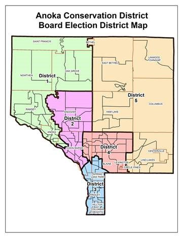
The following districts in Anoka County will be up for election:
District 1 - Anoka, part of Coon Rapids, Nowthen, Oak Grove, Ramsey, St. Francis
District 4 - Portions of Blaine and Coon Rapids, all of Lexington
District 5 - Bethel, Centerville, Circle Pines, Columbus, East Bethel, Ham Lake, Lino Lakes, Linwood Township
Filing is easy but must happen between May 21 and June 4. Just go down to the County Government Center in Anoka during that time and they'll tell you what to do.
For more information read the frequently asked Questions or contact Kathy Berkness, Office Administrator, at
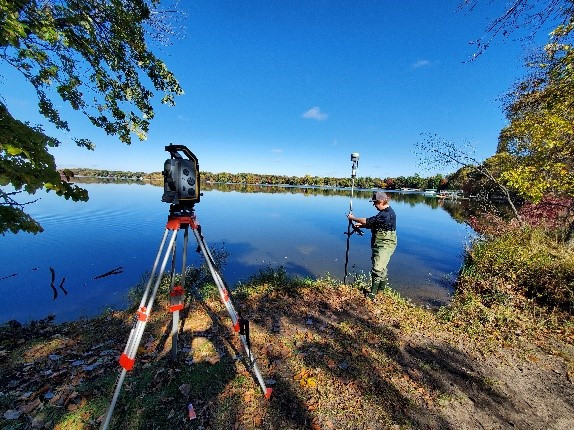
Twenty-years ago we designed conservation projects with a tape measure and graph paper. Over the years, ACD has gone high tech. Today we use a survey-grade GPS (shared with neighboring SWCDs) and landscape design software. This allows precise measurements and estimates of quantities. It also allows us to clearly communicate a project's outcomes to landowners and contractors. But we still pull out the tape measure once in a while – it never crashes or fails to connect.