Balancing Rock and Plants to Stabilize Lakeshores

Wave and ice action, boating activity, fluctuating water levels, sandy soil, and the removal of native shoreline vegetation are all common culprits of erosion on Anoka County's lakeshores. When mowing to the water's edge and clearing emergent vegetation drive erosion, restoring the native shoreline plant community alone can stabilize the lakeshore. Sometimes additional stabilization materials may be warranted. However, a wall of rock riprap is almost never needed to stabilize lakeshores. Too much rock creates a sterile environment in this ecologically vital transition zone between land and water. We achieve the best of both worlds by combining moderate rock with robust native vegetation.
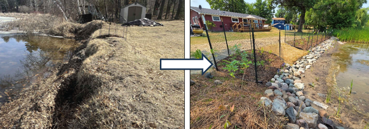
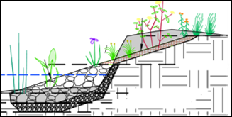
Photo: Lakeshore project before (left) and after (right). Rock provides long-term stabilization for the base of the slope, and native vegetation stabilizes the soil above. Emergent vegetation and vegetated riprap were incorporated to increase ecological value and further stabilize the soil below the rock. An opening in the buffer allows for water and dock access. Temporary fencing will prevent forage pressure from deer, geese, and rabbits while plants establish.
Photo: An excerpt from the project design showing a cross-sectional view of the stabilization components (rock, regrading, and vegetation).

A recently installed project on Linwood Lake showcases this approach. Persistent wave action against the shoreline washed away soil at the base, causing the soil above to collapse into the lake. Over time, this created a vertical slope where vegetation struggled to grow. To address these issues, we installed rock riprap along the shoreline where soil washed away and vegetation struggled to establish. We filled voids between rocks in the uppermost riprap zone with soil and planted vegetation that could handle fluctuating water levels. Above that, we planted a buffer of diverse, deep-rooted vegetation to stabilize the soil. We planted water-loving vegetation in the lakebed to restore the emergent vegetation community, which acts as a valuable wave break for the shoreline behind it.

For more information contact Breanna Keith, Water Resource Specialist, at This email address is being protected from spambots. You need JavaScript enabled to view it..

  109 Hits

Farmed to Flooded

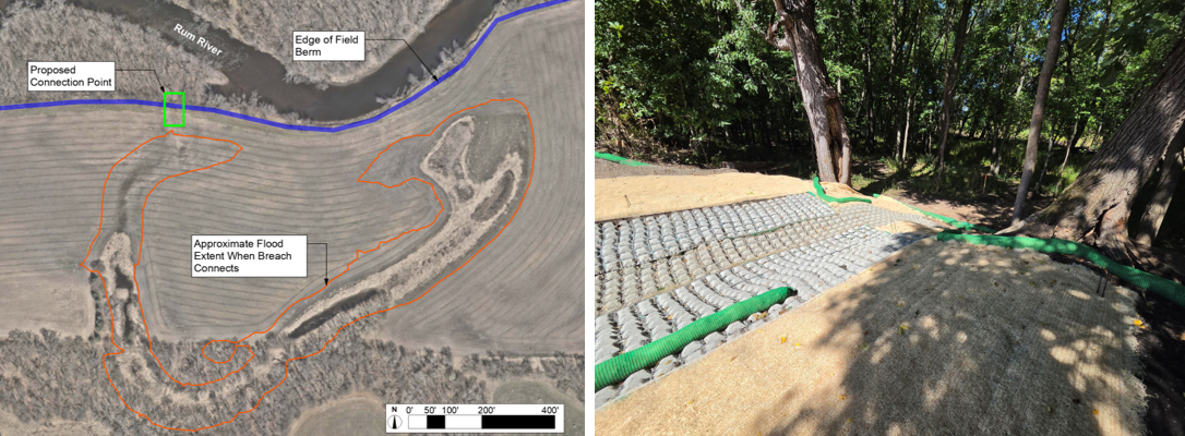
The "Ziegler" oxbow near the City of Princeton has historically been separated from the river via an artificial berm. This berm prevented the river from flooding into the surrounding farm field during spring high water. For decades, the berm improved farm access for planting, but it kept the oxbow dry except during the most severe flood events. The landowner placed the field under a conservation easement and plans to restore it to prairie and woods.

Photo: Aerial view of Ziegler Oxbow (left). Stabilized berm breach point, facing the floodplain (right).

We have partnered with Isanti SWCD, USFWS, and The Nature Conservancy to create a project that will improve connectivity between the Rum River and its floodplain, enhancing over 7 acres of wetland habitat. Construction was completed in mid-September. Now we eagerly hope for high (enough) river levels this coming spring! For more information contact Jared Wagner, Water Resource Specialist, at This email address is being protected from spambots. You need JavaScript enabled to view it..

  107 Hits

Planting Trees This Fall? Learn How to Plant and Care for Your Trees!

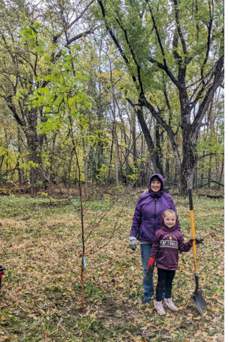
Photo: Volunteer Tree Planting Event at Kings Island in Anoka, MN.

Planting trees benefits both your home and the environment. On your property, trees provide privacy, boost curb appeal, and lower energy costs. On a larger scale, they reduce soil erosion, improve air quality, and provide vital wildlife habitat. The resources below provide helpful tips for tree planting and care.

DNR – Planting Trees and Seedlings. Videos and pocket guides

DNR – Caring for Trees. Watering, mulching, pruning tips, and more!

Looking to get involved in tree planting events this year? Check out ACD's upcoming volunteer events to see how you can help natural resources in your community. Sign up for an event on our Eventbrite page, also linked on the "Volunteer with ACD" page of our website. 

For more inormation contact Lauren Schmelzer, Outreach and NAutural Resource Technician, at This email address is being protected from spambots. You need JavaScript enabled to view it..

  119 Hits

The Hidden Values that Make Conservation Projects Worth More

When you invest in your property, you usually expect one specific result. If you fix a roof, you get a dry house. But what if a property upgrade could do three or four things at once?

Soil and water conservation districts like ACD have the pleasure of working with private landowners on voluntary projects that benefit natural resources – often for one primary purpose while unlocking multiple secondary benefits. 

A few examples illustrate how one project can do more:

  • Water quality + wildlife. One project we did in 2026 was a wetland restoration along a county ditch, designed to capture nutrients before they reached downstream lakes. Sounds like an industrial function. We included shallow water areas and wet prairie seed. Swans, eagles, otters, songbirds, and more have taken up residence.
  • Stormwater treatment + pollinators. Rain gardens capture water from street curbside gutters and filter it into the ground. They are especially used where that water would otherwise reach a lake or river untreated. We plant a variety of flowering native plants. The rain gardens hum with bees and are adorned with butterflies.
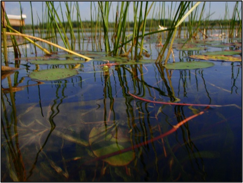
  • Lakeshore + fisheries. Lakeshore restorations stabilize eroding shorelines and restore natural plant cover and habitat. While rock is a common approach to shoreline protection, we use it only where needed most and emphasize habitat-providing plants. Aquatic plants, such as bulrush (pencil reed), are part of the mix. Game fish frequent these shores for cover and insect food.
  • Tree planting + clean water. We annually sell thousands of trees to private landowners. By mixing complementary species, landowners create diverse forests that naturally filter rainwater and protect local waterways.

How do we make conservation projects worth more? By designing them to do more. Yes, our funding sources often focus on just one thing. But we don't have to do just that. ACD strives to produce projects that benefit wildlife, fisheries, water quality, pollinators, and look beautiful too.

At any given time, we focus on specific areas or project types. These priorities have supporting funding to install projects, reducing financial barriers for landowners. Current focuses include wetland restoration in the Rum River watershed and agricultural practices like cover crops.

Ready to maximize your property's potential? Call the Anoka Conservation District at 763-434-2030 to get started on your project design.

  139 Hits

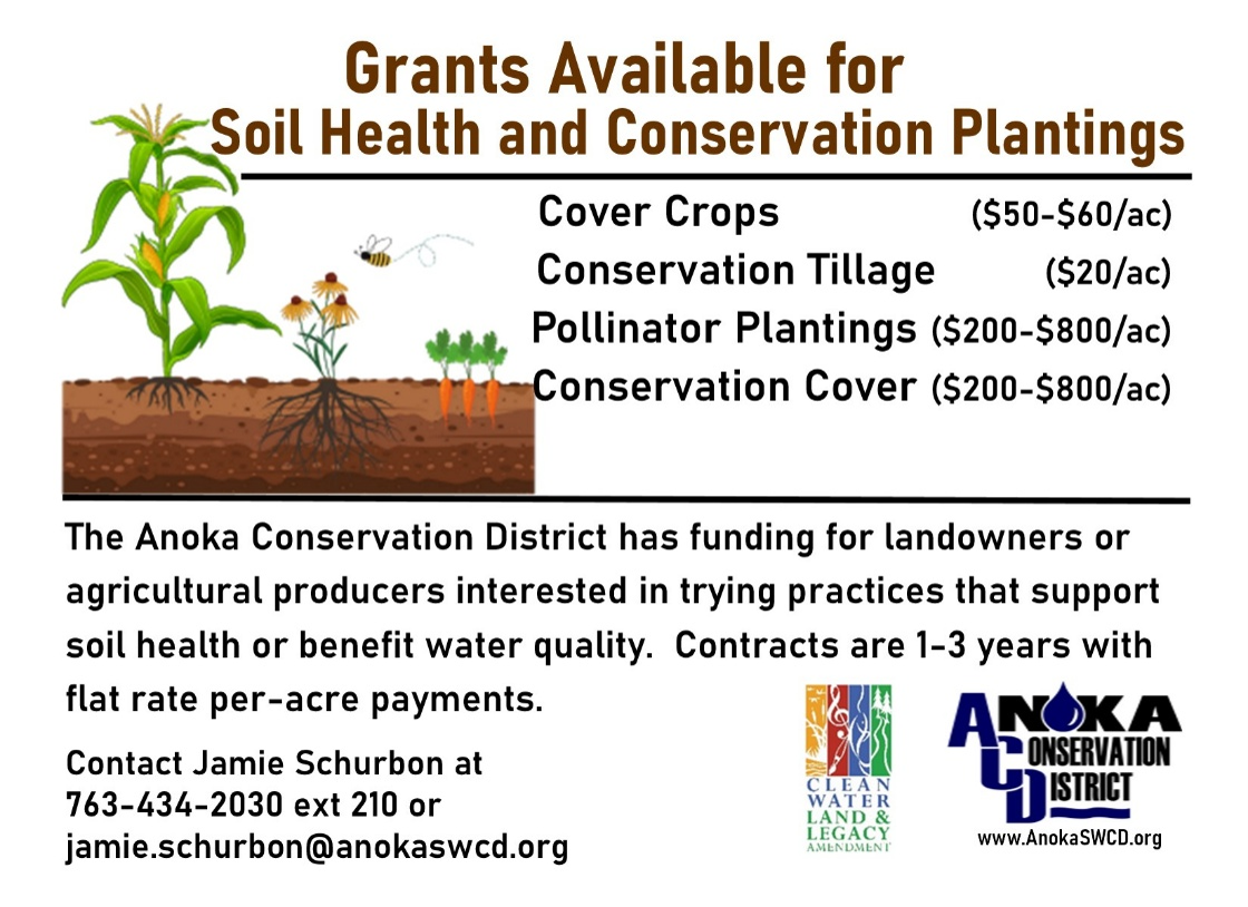
Soil Health and Conservation Planting Grants Available!

  325 Hits

ACD's Meaningful Partnership with Conservation Corps MN

For organizations like ACD, working with a Conservation Corps of Minnesota & Iowa (CCMI) field crew can be much more cost-effective than using contractors for local conservation work and can also help train the next generation of natural resource professionals. The crews are supervised, equipped, and can be assigned to projects lasting from a single day to several months. 

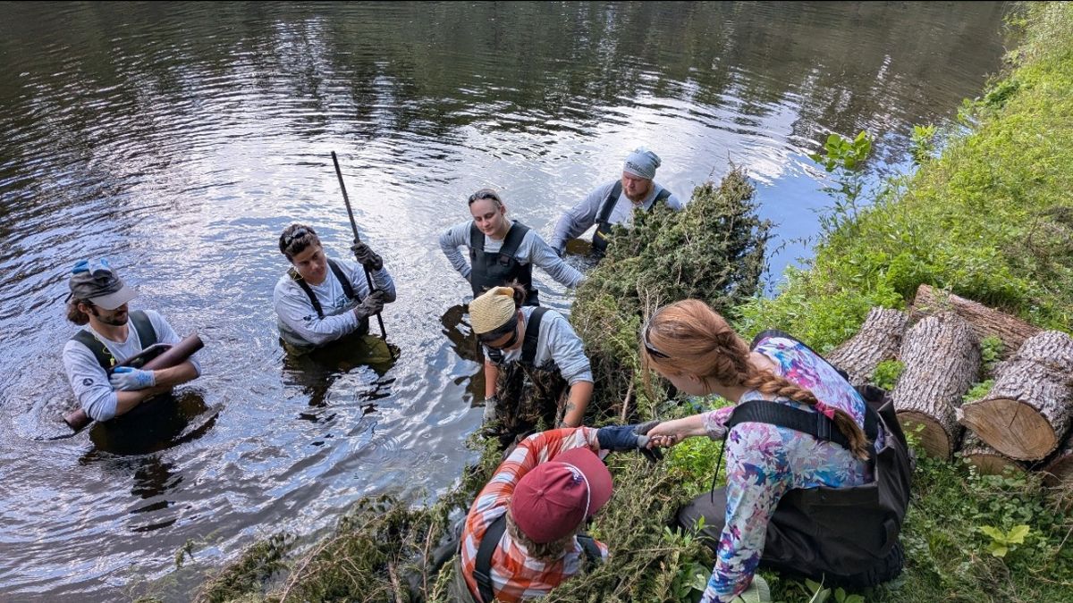
Photo: ACD staff teaching a metro CCMI crew how to install a cedar tree revetment on a private shoreline of the Rum River. This metro crew will work with ACD throughout the summer, allowing them to continue their professional development.

Many young adults join CCMI for a mix of experience, training, student loan benefits, their love of the outdoors and the desire to make a difference. For many professionals in Minnesota, a season with CCMI is a stepping stone to landing permanent jobs in conservation, forestry, parks, or environmental science.

By working alongside the crew members, ACD staff can share their knowledge and experience to provide real mentorship. Check out the CCMI website to learn more about their mission and employment opportunities. For more information contact, Kris Larson, Water Resource Specialist, at This email address is being protected from spambots. You need JavaScript enabled to view it..

  377 Hits

Low-Stakes, Riverbank Stabilizations

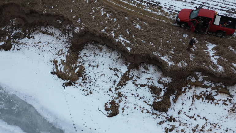
It is easy to recognize large, eroding riverbanks as a problem. Along the Rum River, which flows through the Anoka Sand Plain, twenty-foot-tall cliffs along outer bends are not an uncommon sight. Stabilizing these banks protects the land behind them and keeps soil and nutrients out of the river. Exactly how to approach stabilization is a balancing act unique to each site. 

Photo: Eroding river bank on the Rum River.

At the most extreme, steel and concrete walls are used to protect valuable infrastructure and roads. Rock riprap is a common practice employed to protect homes near eroding shorelines. In some cases, particularly where no infrastructure is at risk, a vegetative approach can be best. These vegetative approaches often require less equipment and cost much less than hard armoring, and they provide additional habitat benefit for wildlife.

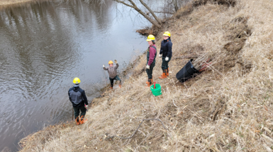
Photo: Conservation Corps crew live staking the toe of an eroding Rum Riverbank.

At a new conservation easement along the Rum River in Isanti County, we employed crew members from Conservation Corps MN & Iowa to plant 600 live willow and dogwood cuttings along the toe of an eroding Rum Riverbank. The riverbank is far from any homes or infrastructure. The land behind the riverbank was a corn field that will be planted with native vegetation. Because the risk of loss at this site is so minimal, we opted for a soft, natural approach over expensive hard armoring. The hope is that the planted stakes will take root and grow, establishing dense tree cover along the lower slope. The upper slope will continue to shift until it reaches equilibrium, but if the toe remains in place, the bank will have a chance to heal and fully revegetate over time. Because the investment of time and materials was so low, we can try again if the stakes die from flooding or drought. 

For more information, contact Jared Wagner, Water Resource Specialist, at This email address is being protected from spambots. You need JavaScript enabled to view it..

  758 Hits

Street Sweeping Studies are Underway

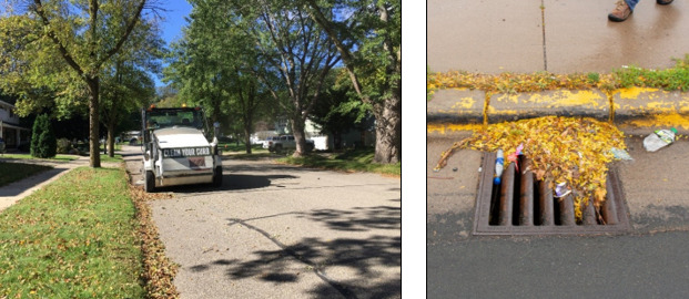
Photo: A street sweeper moving down a street (left). A storm drain partially clogged with yard debris and trash.

Advanced street sweeping studies are being completed by ACD staff to identify locations where strategically increasing the frequency of sweeping would result in the greatest water quality benefits to the Rum and Mississippi rivers. The highest priority areas for this effort are typically those with limited existing stormwater treatment and/or high roadside tree canopy cover, both of which contribute to increased pollutant loads in stormwater. 

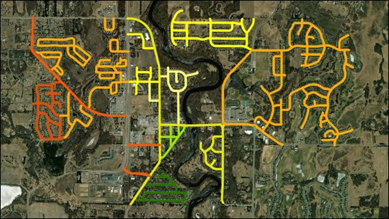
Photo: A street sweeping prioritization map for the City of St. Francis.

The photo above shows a street sweeping prioritization map produced through the enhanced street sweeping analysis for the City of St. Francis; green indicates the highest priority streets, and red indicates the lowest, for achieving water quality improvements to the Rum River. These analyses are also being completed for portions of Ramsey, Andover, and Anoka. Detailed reports and recommendations will be provided to these cities upon the completion of these studies. For more information contact Breanna Keith, Water Resource Specialist, at This email address is being protected from spambots. You need JavaScript enabled to view it.. 
  716 Hits

Turning Buckthorn into Biochar: A New Tool for Restoration

At Soderville Park in Ham Lake, Minnesota, staff from the Anoka Conservation District (ACD) recently tested a new method for disposing of invasive buckthorn. Instead of creating smoky burn piles, they used a biochar kiln called the Ring of Fire.

The Ring of Fire is a type of biochar kiln designed to burn organic material (biomass)—such as wood and plant debris—in a low-oxygen, high-temperature environment. Compared to traditional burn piles, this process is more efficient and significantly reduces smoke, emissions, and environmental impact.

Traditional burn piles turn biomass into ash, which can generate large amounts of smoke, damage soils, and increase erosion. They also leave burn scars on the landscape that can persist for years, creating disturbed areas where invasive species may spread more easily.

How the Ring of Fire Works

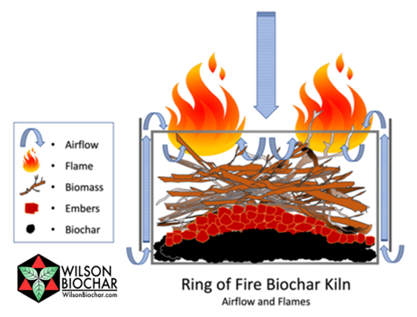
The Ring of Fire works differently. The kiln is packed tightly with sticks and branches and then lit from the top. The flame at the top consumes oxygen from above, while the biomass inside the kiln is superheated with radiant heat. Instead of burning completely to ash, the material below undergoes a process called pyrolysis, in which the heated biomass is transformed into biochar—a stable, carbon-rich material similar to charcoal. 

Photo: Illustration of the burning process created by the Ring of Fire biochar kiln and how it converts biomass into biochar. Illustration from Kelpie Wilson. wilsonbiochar.com

When biochar is incorporated into the soil, that carbon can remain stored for hundreds to thousands of years, effectively locking atmospheric carbon into the ground rather than releasing it back into the atmosphere.

Biochar also provides ecological benefits for the soil. Its porous structure can bind excess nutrients such as nitrates and phosphates, reducing their availability and often favoring invasive plants. By capturing these nutrients, biochar can help slow the spread of invasive species that thrive in nutrient-rich environments.

Restoration Benefits at Soderville Park

At Soderville Park, the Ring of Fire also improved safety during the burning process. Since the fire's heat is at the top of the kiln, using the kiln prevents flames from heating the underlying peat soils, which can smolder underground if ignited.

After the burn, the biochar was spread in areas with high weed pressure. By absorbing excess nutrients in these soils, the biochar may give native plants—many of which are adapted to lower-nutrient conditions—a competitive advantage over invasive species.

By turning buckthorn piles into biochar, the Ring of Fire offers a creative way to support restoration goals while reducing smoke, protecting soils, and storing carbon.

- Article and photos by Lauren Schmeltzer

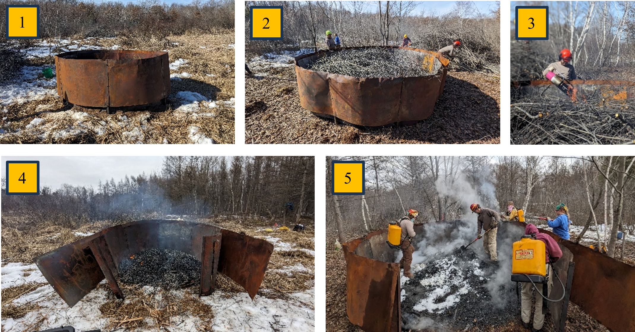
Photo: Shows stepwise burning process using the of Ring of Fire. 1) Construct the Ring of Fire biochar kiln, 2) pack kiln tightly with buckthorn branches and sticks, 3) ignite the biomass in the kiln from the top and continue adding biomass to the pile, 4) once all biomass has been added, let the embers cool and open the Ring of Fire, 5) use water and snow to quench the heat and spread the biochar in the desired area.
  971 Hits

ACD's 2025 Technical Assistance Summary

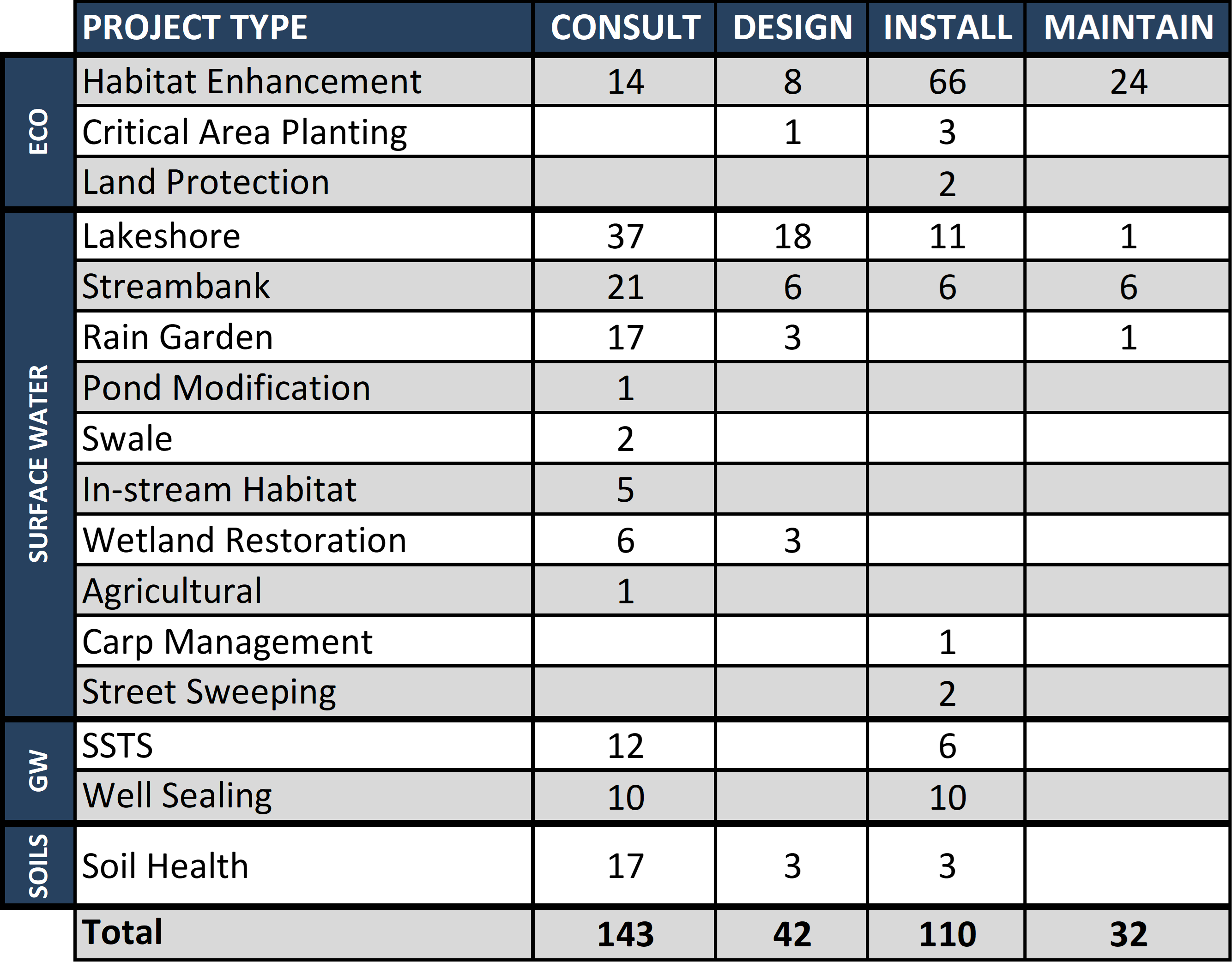
Each year, ACD staff provide technical assistance for projects focused on ecological resources, surface water, groundwater, and soils throughout Anoka County. This work includes ecological projects such as habitat enhancement and critical-area plantings; surface-water projects such as lakeshore improvements, rain gardens, and swales; groundwater protection through well sealing and septic-system upgrades; and soil-related practices such as cover cropping. These projects help enhance habitat, protect water quality, and support healthy natural systems.

Assistance typically begins with a site consultation. This includes a conversation with the landowner, a review of maps and available information about the property, and a site visit to walk the property and discuss options. If a project moves forward, ACD can assist with planning and design, provide installation oversight, and offer guidance on long-term maintenance. These efforts are made possible through collaboration with landowners and partner organizations. The table below summarizes the technical assistance provided by ACD staff in 2025. 

If you have a conservation question or are interested in exploring options for your property, ACD staff are available to help! We look forward to continuing this work in 2026 and supporting positive environmental outcomes throughout Anoka County. For more information, contact Mitch Haustein, Stormwater & Shoreland Specialist, at This email address is being protected from spambots. You need JavaScript enabled to view it..

  838 Hits

Lakeshore Projects Completed on Martin, Linwood, and Coon Lake

Construction has concluded for nine lakeshore stabilization projects on the Sunrise Chain of Lakes: four on Martin Lake, three on Linwood Lake, and two on Coon Lake. Project locations were selected in 2024 based on the property's need for restoration and the anticipated water-quality benefits the project would deliver. Detailed designs were compiled, and three primary bioengineering approaches were applied. 

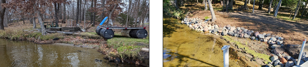
Photo: Shorelines most susceptible to severe erosion from things like wave action, water level fluctuations, and/or sandy soils were regraded to a gentle slope, stabilized at the base with moderately sized fieldstone rock, and planted with native vegetation throughout to provide further stability and habitat benefits.
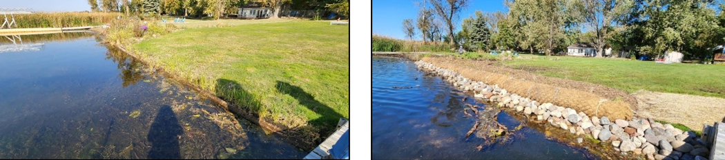
Photo: Shorelines experiencing moderate erosion were stabilized with smaller fieldstone rock to the elevation at which vegetation wouldn’t grow, planted with native vegetation to stabilize the shoreline above the rock, and equipped with a coir biolog to protect from wave action during the plants’ early growth stages.
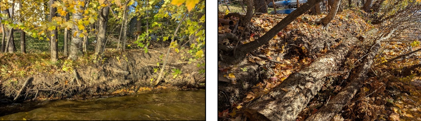
Photo: This shoreline, which exhibited severe undercutting and soil collapse but a healthy community of trees and shrubs above, was stabilized by anchoring large and dense woody materials such as logs, cedar brush bundles, and large tree limbs along the base; these will protect from wave action and provide a bench for soil accumulation to support vegetation growth.

Funding for these projects was through a Clean Water Fund grant, the Sunrise River Watershed Management Organization, Soil and Water Conservation District (SWCD) Aid, and landowner match. For more information contact Breanna Keith, Water Resource Specialist, at This email address is being protected from spambots. You need JavaScript enabled to view it..

  1040 Hits

Rain Garden Construction Video - 225th Lane Outlot, St. Francis, MN

This ACD video showcases a successfully completed rain garden that was built on a city outlot in St. Francis, MN. This rain garden was funded through the Clean Water, Land, and Legacy Amendment, with additional funds from the Upper Rum River Watershed Management Organization. The City of St. Francis will provide project maintenance. This video combines real footage, motion graphics, and 3D animation to showcase the entire construction process and illustrate the process of building a rain garden with an underdrain system. The underdrain system is largely hidden underground, so this video is intended to help inform on what a underdrain system may look like. For more information contact Brian Clark, Natural Resource Technician, at This email address is being protected from spambots. You need JavaScript enabled to view it..

  2330 Hits

Log Revetments Holding Lakeshore in Place

Photo: A log revetment installed on the NE side of Martin Lake.

Addressing eroding slopes along an undeveloped portion of the Martin Lake shoreline required a creative stabilization solution. Sandy soils, wave action (increasing with boat activity), and fluctuating water levels cumulatively drove soil loading to the lake and the gradual encroachment of the shoreline toward the adjacent road. However, site access and workable land upslope was limited, and preserving mature trees and other natural shoreline elements was a priority. To achieve this, sections of stacked logs were anchored to the base of the shoreline along critical eroding areas. 

Photo: Diagram by the Wisconsin Land and Water Conservation Association.

The lower logs act as a barrier to prevent waves from washing out soil at the base of the slope, and the upper logs trap the sandy soil falling from behind – rebuilding the eroded voids and creating a more stable slope within which vegetation can become re-established. At the same time, wildlife such as nesting turtles can still access these areas. ACD staff will continue monitoring this site in the coming years to assess its long-term effectiveness in protecting the shoreline. For more information contact Breanna Keith,Water Resource Specialist, at This email address is being protected from spambots. You need JavaScript enabled to view it..
  2750 Hits

Agricultural Lunch & Learn

  2503 Hits

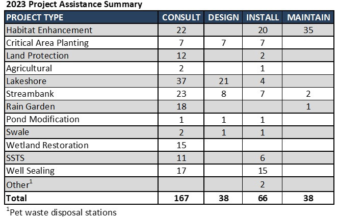
2023 ACD Technical Assistance Summary

ACD staff provide technical assistance for a wide-variety of projects each year. Many of the requests for assistance come directly from landowners interested in improving natural resources on their individual properties. Technical assistance is also provided for projects in collaboration with county, city, and watershed entity partners. The table below summarizes 2023 technical assistance provided by ACD staff. 

Assistance usually begins with a site consultation. Consultations typically include a conversation with the landowner, desktop review of the site using GIS mapping software and available data sets, and a site visit to discuss options. If the landowner is interested in pursuing a project, ACD can provide design and installation oversight services. Maintenance guidance is also provided for previously installed projects.

For more information contact Mitch Haustein, Stormwater & Shoreline Specialist, at This email address is being protected from spambots. You need JavaScript enabled to view it.. 

  2434 Hits

Restoring Wetlands on Your Property

Minnesota is rich in wetlands which provide numerous benefits such as flood mitigation, groundwater recharge, water quality improvement, recreation, and high-quality habitat for a wide variety of fish and wildlife species. However, many wetlands exist in a degraded state due to decades of human disturbances such as drainage and filling to increase usable land for agriculture and urban development.

Recognizing their importance, many federal, state, and local agencies have developed programs to provide technical expertise and funding for wetland restoration projects. The goal of wetland restoration is to return a wetland to its natural functions, and the nature of each project depends on the wetland's unique location, hydrology, soils, vegetation, and impacts (historic and current).

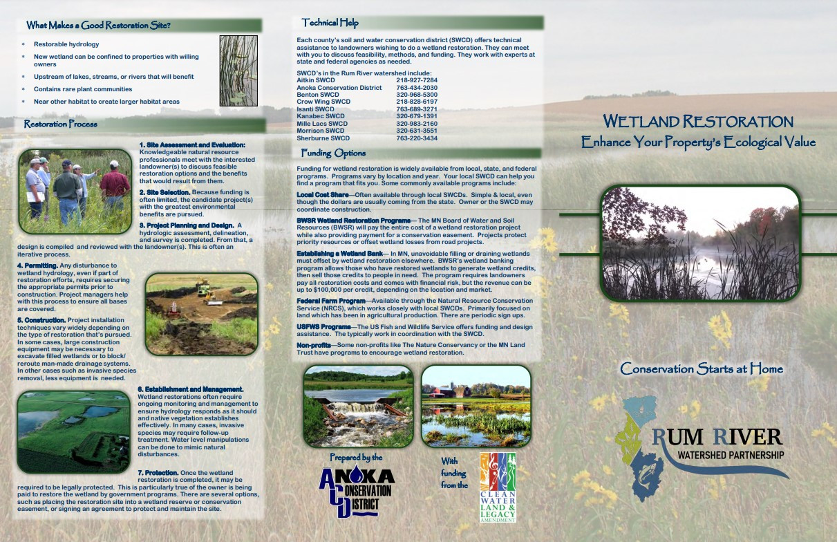
Restoring wetlands on your property adds to its ecological value and can often be financially beneficial. Understanding your options can be complicated, which is why ACD – on behalf of, and with funding from, the Rum River Watershed Partnership – created a new wetland restoration brochure. In it, you will find information on benefits, approaches, processes, and funding options common for wetland restoration projects. Click here to access the brochure below.

Anoka County Residents: ACD currently has funding to support wetland restorations benefitting the Rum River! If you live near the Rum River, believe that you have impacted wetlands on your property, and are interested in restoring them, please contact Breanna Keith, Water Resources Technician, at This email address is being protected from spambots. You need JavaScript enabled to view it. to learn more. 

  3670 Hits

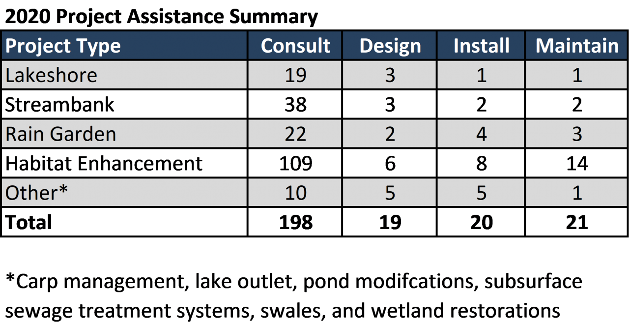
2020 ACD Technical Assistance Summary

ACD staff provide technical assistance for a wide variety of projects each year. Many of the requests for assistance come directly from landowners interested in improving natural resources or addressing concerns on their properties. Technical assistance is also provided for projects in collaboration with county, city, and watershed entity partners. The table to the right summarizes 2020 technical assistance provided by ACD staff.

Assistance begins with a site consultation. Consultations typically include a conversation with the landowner, desktop review of the site using GIS mapping software and available data sets, and a site visit to discuss options. If the landowner is interested in pursuing a project, ACD can provide design and installation oversight services. Maintenance guidance is also provided for previously installed projects.

Additional information about active projects and those previously completed is available on ACD's project tracking map.

https://www.arcgis.com/apps/Shortlist/index.html?appid=d1e76c3d808743c1b149bde24c990894

  3143 Hits