Dellwood River Park Shoreline Stabilization – Project Update

A design has been finalized to stabilize 650-feet of eroding Rum Riverbank at Dellwood River Park in St. Francis. Erosion of the riverbank is causing numerous trees to fall into the river and is threatening a popular walking trail. The project design, currently in the permitting phase, features three primary protection measures;

  • 1) Two severely eroding zones of riverbank encroaching on the trail will be built back out, armored with rock riprap, and potentially have large tree root-wads added to provide in-stream habitat elements. The riprapped length of bank will total approximately 180-feet in length.
  • 2) Three bendway weirs constructed of rock will protrude at a 45° into the river. These low-lying, linear features will be submerged under the water, and will push flow and erosive scour back toward the middle of the channel, rather than along the outer bank. The bendway weirs will also add variable flow areas and habitat value in the channel. These will be great features to cast around for any fisher folks from shore!
  • 3) And finally, the less severe eroding areas of riverbank will be armored with cedar trees in a technique called a "cedar tree revetment". Cut eastern red cedars will be cabled together in a shingled fashion along the bank and secured with earth anchors driven into the soil. This is a bioengineering approach that is softer and less expensive than rock which should help the bank stabilize, vegetate, and stabilize over time before the cedar trees eventually rot away.

For more information contact Jared Wagner at 763.434.2030 ext.200 or This email address is being protected from spambots. You need JavaScript enabled to view it..

  2128 Hits

Minnesota Gets New LiDAR Data

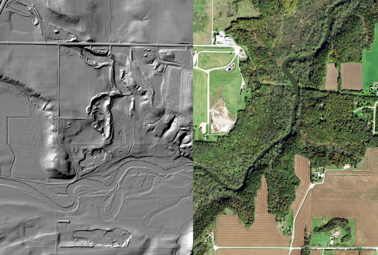
LiDAR stands for Light Detection and Ranging. The landscape is mapped by laser pulses projected from a low-flying airplane. These pulses bounce back to a sensor which records the location of the airplane, the angle of the pulse, and the time it takes the light to bounce back. Using that information, the system is able to create a point cloud of the landscape. This point cloud is then converted into modeled surface of the ground called a Digital Elevation Model (DEM). This model can be used to map terrain features like water flow paths and drainage areas, geologic features, infrastructure, and many others.

The first generation of LiDAR data in Minnesota was collected from 2008-2012. Since then, the landscape has changed in untold ways, and technology has dramatically improved for collecting more dense and accurate data. Because of this, the 3D Geomatics Committee of the State's Geospatial Advisory Council set out to coordinate the collection of Generation 2 LiDAR in Minnesota. This effort is currently underway in partnership with the USGS as the lead data collection entity nationally, and counties and other local partners as the ultimate data recipients. Generation 2 LiDAR data collection started in 2021. Anoka County data was collected in 2022, and will be available in 2023.

This new data will allow us to map watercourses, drainage areas, and floodways in much higher resolution and with more accurate and recent data from the landscape. We'll also be able to assess eroding slopes like those along riverbanks for height, steepness, and stability without having to traverse them with survey gear. Because the new data is so robust, it is also opening up possibilities for forestry and vegetation surveys, very detailed mapping of infrastructure, and untold uses yet to be implemented or even thought of.

For more information about this incredibly useful public data, visit the Minnesota LiDAR Hub online at: https://lidarhub-minnesota.hub.arcgis.com/ 

LiDAR produced Digital Elevation Model (DEM) left, aerial photography right, along a river in Minnesota.
  5106 Hits
Tags:

Assistance for Shoreline Erosion

The Anoka Conservation District (ACD) currently has a number of grant opportunities available for addressing shoreline erosion along streams and lakes in Anoka County. If you have noticed your lakeshore migrating backwards over time, or perhaps you once had a low walkable area along your river frontage that is now gone, ACD may be able to help design and even fund a project to protect your property.

The first step is a site visit to your property by ACD staff. Now is a great time to reach out to the district and plan a site visit for the spring. ACD staff will assess erosion problems, provide professional advice, and determine if your shoreline might qualify for financial assistance through one of our various grant programs. Shoreline restorations don't just benefit your property but also help improve water quality in your lake or river and enhances habitat for wildlife. 

For more information contact Jared Wagner,  763.434.2030 x200, This email address is being protected from spambots. You need JavaScript enabled to view it.

  2225 Hits

2022 – A Year of Water Quality Projects and Benefits

 This past year, ACD was again busy installing projects that benefit water quality in Anoka County! In total, 33 individual water quality projects were installed in 2022, including:

  • 12 curb-cut rain gardens, treating 25.9 acres of urban area draining to the Rum River and Rice Creek.
  • 9 streambank stabilization projects, and 2 streambank buffer plantings protecting and enhancing over 2,000 linear feet along the Rum and Mississippi Rivers.
  • 10 Lakeshore stabilizations and buffer plantings along 824 feet of lakeshore on George, Martin, Linwood, and Fawn Lakes.

Collectively, these projects will reduce annual pollutant loading to the receiving waterbodies by 94.9 tons of total suspended solids, and 88.6 pounds of total phosphorus. To see all of our projects, watch for our new Water and Ecological Project Dashboards, coming soon to our website!

Photos of some water quality projects newly installed in 2022 – rain garden (top left), lakeshore (bottom left), and streambank stabilizations (top right, bottom right).

ACD Contact: Jared Wagner, This email address is being protected from spambots. You need JavaScript enabled to view it.

  1952 Hits

Rum Riverbank Washout Stabilized Near Rum River Central Boat Ramp

In May of 2022, the Rum River reached its highest peak flow since 2001 following torrential rain events in Isanti and Mille Lacs Counties. The roadway to the boat ramp in Rum River Central Regional Park in Anoka County was inundated under feet of water. When the floodwaters receded, 90 linear feet of bank had completely washed out, threatening the roadway and boat ramp, and leaving and exposed eroding bank dumping sediment into the river. This section of washed out riverbank was stabilized using a Flexamat PLUS articulated concrete mat at the toe, and a regraded and native-seeded slope above. A rock barb installed at the downstream end will provide in-channel habitat for fish and invertebrates while also kicking flow out away from the boat ramp.

The Flexamat articulated concrete was chosen for this project because an immediately adjacent project installed in 2015 is still holding very successfully, even after the flooding. An advantage of Flexamat vs. rock is that the Flexamat has void spaces that allow vegetation to grow between the blocks, masking the concrete during low water conditions, and providing additional habitat benefit. Traditional riprap does not allow this vegetation growth, and can look like a rock wall during low water.

In the spring, we will add bare root seedlings of shoreland tree and shrub species to the project site. The native grasses and sedges seeded into the bank will begin to grow, and the whole bank will establish deep-rooted native vegetation which will keep the soil anchored for years to come. A video short of this project can be found on ACD's YouTube page: https://www.youtube.com/shorts/eUHBV5TSNi8. To see other streambank stabilization projects installed throughout Anoka County, please see the virtual project tour on ACD's website. 

Before (top) and after (bottom) of 90-feet of streambank stabilized at Rum River Central Regional Park.
  2492 Hits