Getting a Better View from the Water

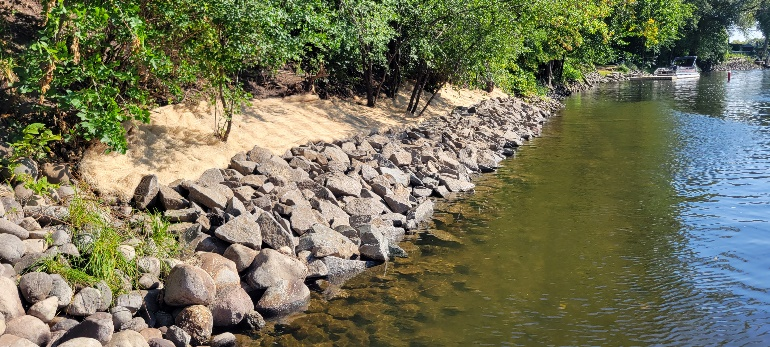
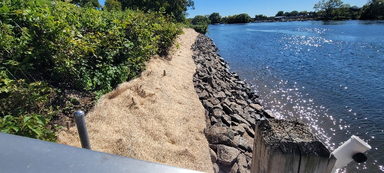
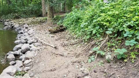
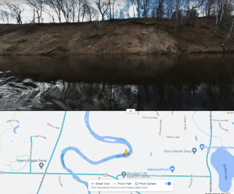
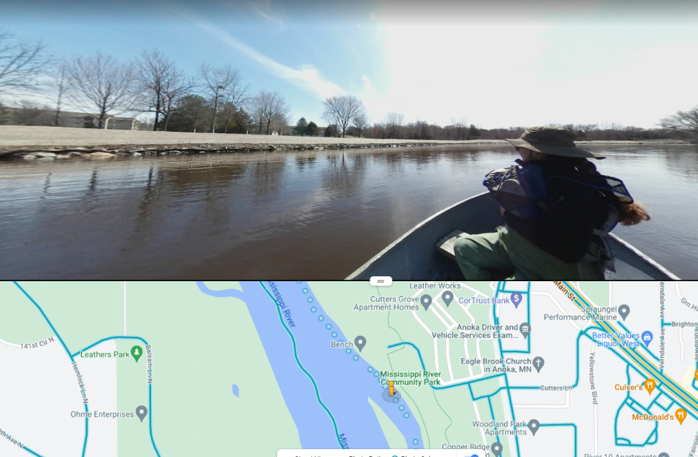
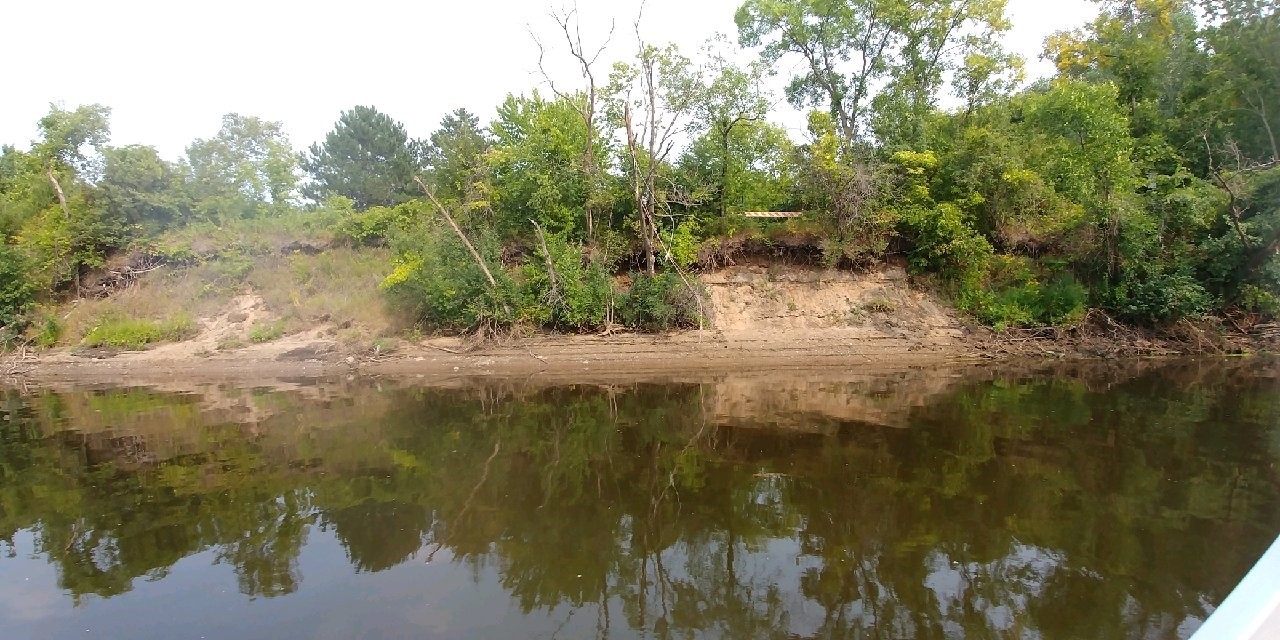
Inventorying shoreline zones on surface waters throughout Anoka County serve as valuable tools for assessing lakeshore and riverbank conditions, comparing current conditions to previous years to identify changes, and for prioritizing project implementation. ACD recently purchased a 360° video camera that has 4 high-definition lenses and a rugged design, to be used outside in the elements. The camera takes continuous video that is Geo-located and stitched together creating a final GPS video that is viewable from all angles. Following a day on the water with the 360° camera, videos are uploaded to Google Street View Studio, a new application recently released by Google. 

Like a Road That Shows Up Blue in Google Street View, You Can Place the Person Down on the Blue Track on the Water Body
Oak Glen Creek, Fall, 2023. You Can Click or Use Keyboard Arrows To Move Your Way From One Image To The Next

Once uploaded to the Google Studio App, the videos are public and accessible to anyone. ACD utilizes these videos to compile shoreline reports, which describe erosion severity and provide recommendations for project needs. Shoreline videos along Martin, Coon, Linwood Lake, the southern portion of the Mississippi River, and Oak Glen Creek were collected throughout 2023 and are now available to view. Click on the individual links above to begin exploring. Videos along the Rum River were also collected and will be available to the public soon!

For more information contact Kris Larson, Water Resource Specialist, at This email address is being protected from spambots. You need JavaScript enabled to view it.. 

  790 Hits

Rum Riverbank Washout Stabilized Near Rum River Central Boat Ramp

In May of 2022, the Rum River reached its highest peak flow since 2001 following torrential rain events in Isanti and Mille Lacs Counties. The roadway to the boat ramp in Rum River Central Regional Park in Anoka County was inundated under feet of water. When the floodwaters receded, 90 linear feet of bank had completely washed out, threatening the roadway and boat ramp, and leaving and exposed eroding bank dumping sediment into the river. This section of washed out riverbank was stabilized using a Flexamat PLUS articulated concrete mat at the toe, and a regraded and native-seeded slope above. A rock barb installed at the downstream end will provide in-channel habitat for fish and invertebrates while also kicking flow out away from the boat ramp.

The Flexamat articulated concrete was chosen for this project because an immediately adjacent project installed in 2015 is still holding very successfully, even after the flooding. An advantage of Flexamat vs. rock is that the Flexamat has void spaces that allow vegetation to grow between the blocks, masking the concrete during low water conditions, and providing additional habitat benefit. Traditional riprap does not allow this vegetation growth, and can look like a rock wall during low water.

In the spring, we will add bare root seedlings of shoreland tree and shrub species to the project site. The native grasses and sedges seeded into the bank will begin to grow, and the whole bank will establish deep-rooted native vegetation which will keep the soil anchored for years to come. A video short of this project can be found on ACD's YouTube page: https://www.youtube.com/shorts/eUHBV5TSNi8. To see other streambank stabilization projects installed throughout Anoka County, please see the virtual project tour on ACD's website. 

Before (top) and after (bottom) of 90-feet of streambank stabilized at Rum River Central Regional Park.
  720 Hits

Stabilizing Riverbanks in Anoka

Construction is complete on six streambank toe stabilization projects on the Rum and Mississippi Rivers in Anoka. These sites have had significant and accelerating erosion in recent years due to sustained high water and recreational watercraft. Most of the sites lie between two popular boat launches on the rivers.

Cumulatively, over 720 linear feet of eroding riverbank was stabilized. The primary stabilization technique is rock riprap installed on the lower portion of the slope, with a seeded and blanketed vegetative zone above the rock. The primary immediate goal of these projects was to halt the backwards march of the riverbanks by stabilizing the lower portion (or toe). An additional vegetation component is planned for these sites in the following year(s) to help stabilize the upper slope, which is only subject to wave action during the highest water periods. This vegetative zone will be comprised of native woody species, as well as grasses, sedges, and forbs, to enhance the habitat and aesthetic value of the shorelines, while also providing deep root structure to anchor the soil in place above the rock. 

The projects were done via barge from the water, a first for ACD-managed projects. Many of these sites had been on our inventories, but were not cost-effectively constructible from land. With a contractor that can install projects from the water, concerns about equipment access between buildings and site restoration on individual properties are non-factors. Beyond stabilizing these six eroding shorelines, we are hopeful that this new construction technique opens up more potential streambank stabilization projects that would have otherwise not been possible or cost-effective from land. To see these and other streambank stabilization projects installed throughout Anoka County, please see the virtual project tour on ACD's website. 

  891 Hits

KNOW YOUR SHORELINE

Minor erosion at the toe of slope exposed during low water. If the erosion is addressed early, larger bank failures in the future may be avoided.

If you live on water, whether it be a lake, river, creek, or stormwater pond, low water during the summer months can provide a great opportunity for you to conduct a quick inspection of your shoreline condition. The very bottom of your shoreline, where it meets the water, is called the toe and is the most critical part for stability.

Low water often exposes the toe of the slope and allows you to identify areas of concern. For example, you might observe undercutting, where the lowest portion of the bank has been scoured away by flowing water or wave action. When problems are caught early, the solutions are often much simpler and cheaper. Addressing erosion concerns early also helps prevent more severe bank failures down the road.

Another good time to inspect your bank is in the fall once leaves have fallen and before snowfall. You can inspect the upper portions of your bank for problems like rutting from concentrated overland flow over the top of the bank.

If you have any questions about your shoreline or think a site visit may be warranted, please contact ACD staff. We're here to help. 

  757 Hits

Native Plantings Added to Streambank Stabilization Sites

Image sourced from MNDNR Stream Habitat Program

Last year, over 3,000 linear feet of cedar tree revetments were installed on the banks of the Rum River in Anoka County. While the cedar trees themselves will help capture sediment and prevent further erosion throughout the coming years, the re-establishment of native riparian vegetation is essential for promoting long-term bank resiliency. In May, ACD staff, with assistance from Anoka County Parks staff, planted a total of over 1,000 plants across six cedar revetment sites; species planted included sandbar willow, red osier dogwood, false indigo, and buttonbush (pictured below). 

When present, the deep roots of native trees, shrubs, grasses, and other vegetation act like a net, securing the bank's soils and preventing them from washing away. Streambank vegetation also provides essential habitat for many aquatic and terrestrial species. For these reasons, ACD incorporates native plantings into all streambank stabilization projects.

Images sourced from Minnesota Wildflowers. © Peter M. Dziuk
  1036 Hits

“Google River View”: 360° Photos Collected on the Rum and Mississippi

An actively eroding bank on the Rum River

Photos collected from near-shore zones on surface waters throughout the county serve as valuable tools for assessing lakeshore and riverbank conditions. Following a day in the boat with a 360° camera, these photos are uploaded to Google Street View, making them accessible to anyone. ACD then uses these them to compile erosion inventory reports, which describe erosion severity and stabilization project needs on high-priority waterbodies such as the Rum and Mississippi Rivers. Updated photos for these rivers were collected throughout the first week of May and are now available to view (alongside those captured in previous years) on Google Maps.  

While browsing through these photos, you are sure to see a beautiful river view. You may also notice banks currently experiencing noticeable erosion or, alternatively, portions that have recently been stabilized and planted with native vegetation.

A formerly failing riverbank at the Mississippi River Community Park in Anoka, stabilized and planted with native vegetation
  1441 Hits

Clean Water Funds for Eroding Rum Riverbanks

The Board of Water and Soil Resources (BWSR) is recommending $440,000 in funding to ACD from the Clean Water Fund[1] competitive grant fund for stabilizing eroding Rum Riverbanks. This funding will be used in conjunction with funds already received from the Lessard-Sams Outdoor Heritage Council[2] ($816,000 to ACD) and the DNR Conservation Partners Legacy[3] grant ($185,000 to Anoka County Parks) for Rum Riverbank stabilization and habitat enhancement projects. These three funding sources will cover projects of all sizes, from small banks only needing cedar tree revetments to large failing banks requiring sophisticated engineering and reconstruction. The funds from the Clean Water Fund grant will be prioritized for the latter.

With additional matching funds from Anoka County, the Upper and Lower Rum River WMOs, ACD and landowners, over $1.5M-worth of streambank projects will be installed over the next three years to help the Rum River. The Rum River is a highly prized resource in Anoka County, but it is on the brink of impairment for phosphorus concentrations, and it has extensive bank erosion. The sediment washing into the river from these eroding banks dirties the water, increases nutrients, and smothers habitat for aquatic wildlife. ACD performed a streambank erosion analysis[4] from 2017 to 2019 that led to this concerted effort by ACD and Anoka County to secure state grant funding and local matching funds to make a big push to help the River. 

  1396 Hits

ACD Partnering with City of Anoka for Mississippi Riverbank Stabilization

Approximately 1,500 linear feet of eroding riverbank within Mississippi River Community Park in Anoka will be stabilized in 2021. The project is currently in the early stages of design and focuses on a stretch of severely eroding riverbank that was documented in an erosion inventory completed by ACD.

Eroding river banks contribute to the Mississippi River's sediment and turbidity impairments through direct loading of sediment and nutrients that degrade overall water quality as well as aquatic and nearshore habitat. Stabilization of actively eroding riverbanks is one of the most cost-effective practices to improve water quality because 100% of the sediment reaches the waterway.

Stabilization techniques will include bioengineering with native vegetation and a rock armored bottom of slope to stabilize the riverbank. The project will reduce pollutants by 529 tons of sediment and 847 pounds of phosphorus annually. Other benefits include aquatic life diversity and abundance, and improved drinking water quality because the project site is immediately upstream of drinking water intakes for the Twin Cities.

This project will also showcase river stewardship and enhance public recreation. Mississippi River Community Park and adjacent Anoka-owned King's Island include 1.7 miles of Mississippi River trail, 0.78 miles of riverfront, 0.91 miles of oxbow channel, pedestrian access to the island, sporting fields, public duck and deer hunting, and a fishing dock. This project will make over ¼ mile of unsafe riverbank more accessible, stable, and fishable for users. By naturalizing the riparian zone, this project complements the Mississippi River Corridor Critical Area rules.

The project is funded by a Clean Water Fund grant, a Watershed Based Funding grant, and match from the City of Anoka. Watch for more updates from ACD and the City of Anoka as the project progresses.

  1144 Hits