More than a River - It's a Trail

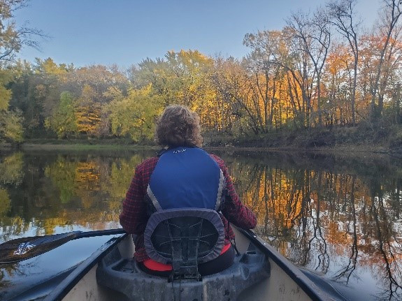
Watershed Projects Manager, Jamie Schurbon, Enjoying the Rum River State Water Trail With His Family

In Anoka County, the Rum and Mississippi Rivers are designated State Water Trails. Like many state trails, information is available about trail access, places to camp, culturally significant areas, and more on the MNDNR's water trails website. ACD is completing a number of projects along both rivers to improve water quality and habitat. We've been especially busy with projects along the Rum River that include wetland restorations, riverbank stabilizations, invasive species management, and habitat protection. Many of these projects are funded in part by the Clean Water, Land and Legacy Amendment.  

  468 Hits

Project Update: Apex Pond Enhancement

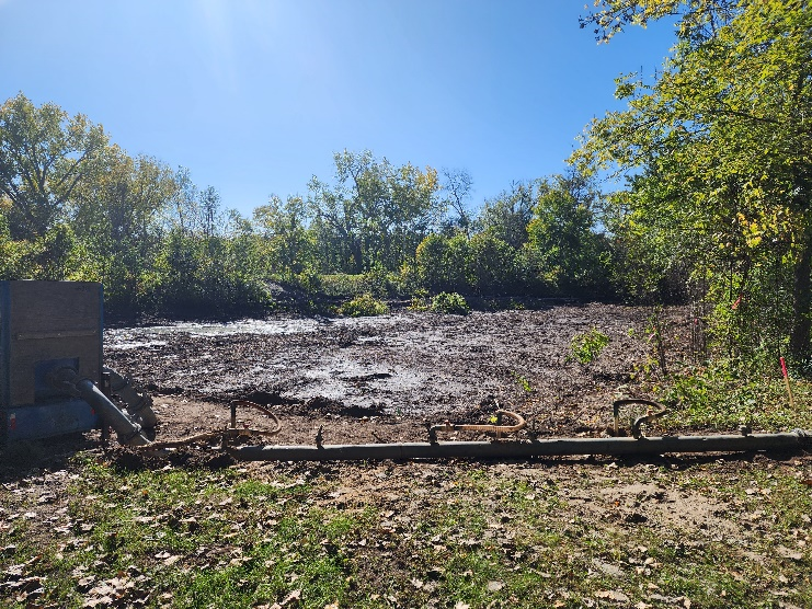
September, 2023 - De-watering of Current Pond, Tree Removal  
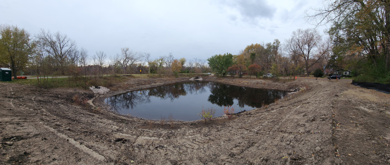
October, 2023 - Water Storage Capacity Increased, Plantings to Come

Construction of the Apex Pond enhancement project in the City of Fridley is nearly complete (see pictures above). The only remaining elements are to spread native seed and lay erosion control blanket over the upper slopes surrounding the pond. Apex Pond in the City of Fridley was originally constructed in 1999 to help control the rate of stormwater runoff entering Springbrook Creek from nearly 90 acres of residential neighborhoods. ACD, in partnership with the City of Fridley and the Coon Creek Watershed District (CCWD) identified an opportunity to enhance the water quality treatment capacity of Apex Pond by increasing the pond's storage volume.

You can also check for project updates on the City of Fridley's website: https://www.fridleymn.gov/1655/Apex-Pond-Enhancement-Project.

For more information contact Mitch Haustein, Stormwater and Shoreland Specialist, at This email address is being protected from spambots. You need JavaScript enabled to view it..
  966 Hits

PROJECT UPDATE - RIVERBANK STABILIZATION IN MISSISSIPPI RIVER COMMUNITY PARK, ANOKA

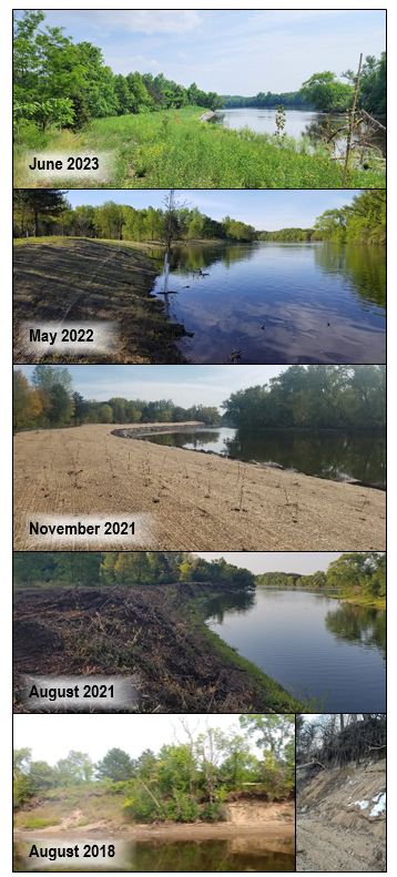
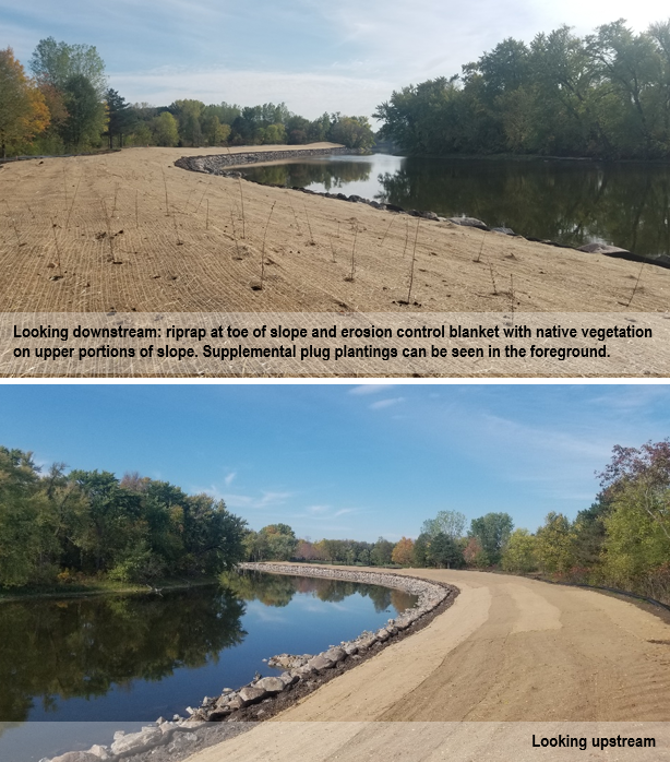
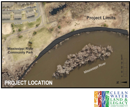
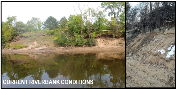
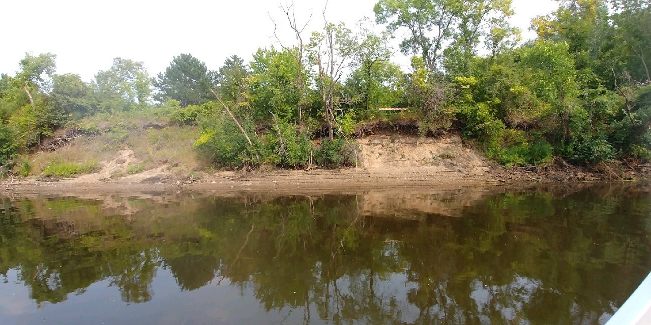
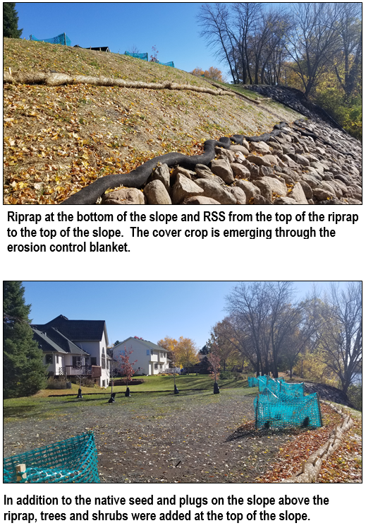
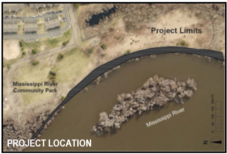
Approximately 1,500 feet of severely eroding riverbank in Mississippi River Community Park was stabilized in late 2021. The project included tree clearing, bank reshaping, riprap, erosion control blanket, seeding, and planting of a variety of native plant species.

Since installation, the site has been subjected to high water in 2022 and 2023. Both the riprap on the lower elevations of the bank and the vegetation on the upper elevations have successfully stabilized the site.

Moving forward, you may observe some vegetation maintenance to help the native species establish. Some examples include supplemental planting of native species and mowing to a height of approximately 6" to limit weed species from dispersing seed.

The project was funded by a Clean Water Fund grant, a Watershed Based Funding grant, and match from the City of Anoka. 

For more information about the project contact Mitch Haustein at This email address is being protected from spambots. You need JavaScript enabled to view it. or 763.434.2030 x150

  730 Hits

Stabilizing Riverbanks in Anoka

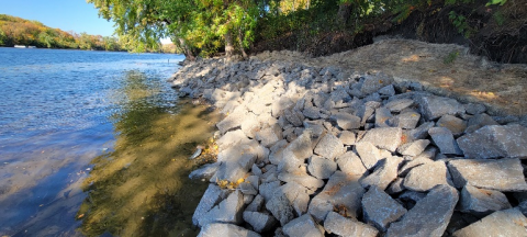
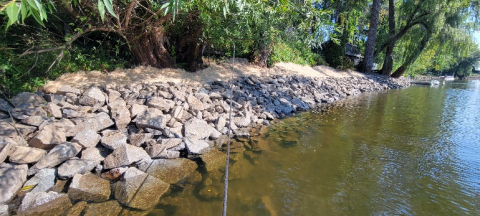
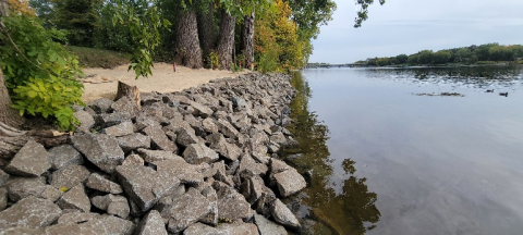
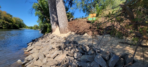
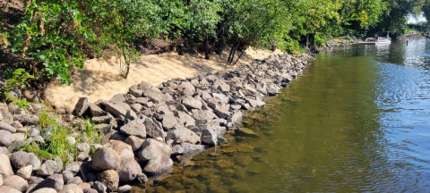
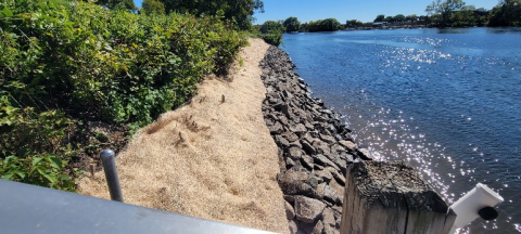
Construction is complete on six streambank toe stabilization projects on the Rum and Mississippi Rivers in Anoka. These sites have had significant and accelerating erosion in recent years due to sustained high water and recreational watercraft. Most of the sites lie between two popular boat launches on the rivers.

Cumulatively, over 720 linear feet of eroding riverbank was stabilized. The primary stabilization technique is rock riprap installed on the lower portion of the slope, with a seeded and blanketed vegetative zone above the rock. The primary immediate goal of these projects was to halt the backwards march of the riverbanks by stabilizing the lower portion (or toe). An additional vegetation component is planned for these sites in the following year(s) to help stabilize the upper slope, which is only subject to wave action during the highest water periods. This vegetative zone will be comprised of native woody species, as well as grasses, sedges, and forbs, to enhance the habitat and aesthetic value of the shorelines, while also providing deep root structure to anchor the soil in place above the rock. 

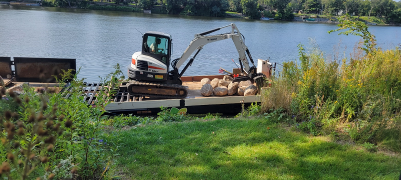
The projects were done via barge from the water, a first for ACD-managed projects. Many of these sites had been on our inventories, but were not cost-effectively constructible from land. With a contractor that can install projects from the water, concerns about equipment access between buildings and site restoration on individual properties are non-factors. Beyond stabilizing these six eroding shorelines, we are hopeful that this new construction technique opens up more potential streambank stabilization projects that would have otherwise not been possible or cost-effective from land. To see these and other streambank stabilization projects installed throughout Anoka County, please see the virtual project tour on ACD's website. 

  881 Hits

Stabilizing Riverbanks in Anoka

Construction is beginning on six streambank stabilization projects on the Rum and Mississippi Rivers in Anoka. These sites have had significant and accelerating erosion in recent years due to sustained high water and recreational watercraft. Most of the sites lie between two popular boat launches on the rivers.

Cumulatively, over 720 linear feet of eroding riverbank will be stabilized. The primary stabilization technique will be rock riprap on the lower portion of the slope, with a seeded and blanketed vegetative zone above the rock. This vegetative zone will be comprised of native species of grasses, sedges, and forbs to enhance the habitat and aesthetic value of the shorelines, while also providing deep root structure to anchor the soil in place above the rock. 

Mini excavator applying rock to a shoreline on the Mississippi River via barge

The projects will be done via barge from the water, a first for ACD-managed projects. Many of these sites had been on our inventories, but were not cost-effectively constructible in a typical fashion from land. With a contractor that can install the project from the water, concerns about equipment access between buildings and site restoration on individual properties are non-factors. Beyond stabilizing these six eroding shorelines, we are hopeful that this new construction technique opens up more potential streambank stabilization projects that would have otherwise not been possible from land.

Project updates will be provided as construction progresses. To see these and other streambank stabilizations projects already installed throughout Anoka County, please see the virtual project tour on ACD's website. 

  1170 Hits

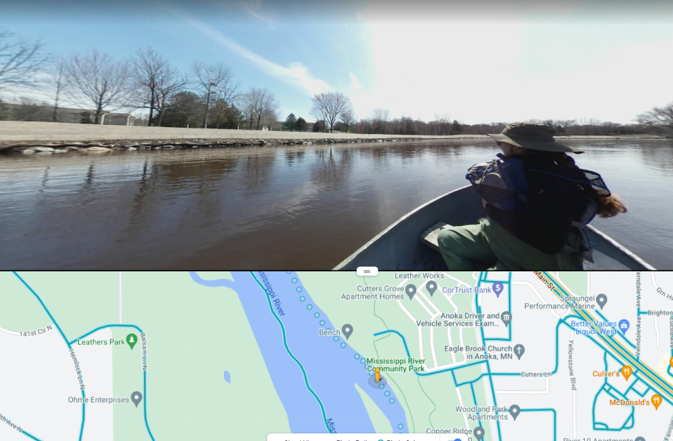
“Google River View”: 360° Photos Collected on the Rum and Mississippi

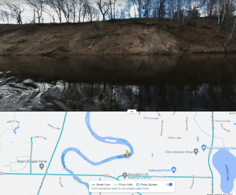
An actively eroding bank on the Rum River

Photos collected from near-shore zones on surface waters throughout the county serve as valuable tools for assessing lakeshore and riverbank conditions. Following a day in the boat with a 360° camera, these photos are uploaded to Google Street View, making them accessible to anyone. ACD then uses these them to compile erosion inventory reports, which describe erosion severity and stabilization project needs on high-priority waterbodies such as the Rum and Mississippi Rivers. Updated photos for these rivers were collected throughout the first week of May and are now available to view (alongside those captured in previous years) on Google Maps.  

While browsing through these photos, you are sure to see a beautiful river view. You may also notice banks currently experiencing noticeable erosion or, alternatively, portions that have recently been stabilized and planted with native vegetation.

A formerly failing riverbank at the Mississippi River Community Park in Anoka, stabilized and planted with native vegetation
  1416 Hits

RAIN GARDENS FOR RICE CREEK - UPDATE

Six rain gardens will be constructed on residential properties in a City of Fridley neighborhood adjacent to Rice Creek in 2022. The properties were identified as priority rain garden locations in the Lower Rice Creek Stormwater Retrofit Analysis (SRA) completed by Anoka Conservation District in partnership with RCWD.

The priority rain garden locations identified in the SRA were used to target landowners for rain garden installation in conjunction with a mill and overlay project in the same neighborhood. Based on landowner interest, ACD provided site assessments and designs, which resulted in the six rain gardens to be installed.

Stormwater runoff that flows by each of the rain garden locations is currently piped directly to Rice Creek. Curb-cut rain gardens at these locations will provide reductions in runoff volume, total suspended solids, and total phosphorus reaching Rice Creek, Locke Lake, and ultimately the Mississippi River. Cumulatively, the contributing drainage area to the six proposed rain garden locations is nearly five acres and comprised of medium-density residential land use.

Because this area of the watershed is fully developed, large regional options for treatment are limited. The six proposed rain garden locations are optimally positioned because they have large contributing drainage areas for the neighborhood, provide sufficient space for appropriately sized rain gardens, have minimal utility conflicts, and either have appropriate underlying soils for infiltration or are adjacent to a storm drain for filtration.

ACD staff worked with landowners of the six properties to size rain gardens appropriately for each contributing drainage area and position the rain gardens in approved locations. Designs accounted for existing landscaping, yard slope, underlying soils and utilities, and landowner requests. Planting plans were also developed in collaboration with landowners to incorporate requested native species.

The project will be funded through a combination of the Rice Creek Watershed District's Water Quality Grant Program and the City of Fridley. The landowners will be responsible for ongoing maintenance of the rain gardens.

Watch for additional updates as the rain gardens are installed in 2022. To see other rain gardens already installed throughout Anoka County, please see the virtual project tour on ACD's website. 

  905 Hits

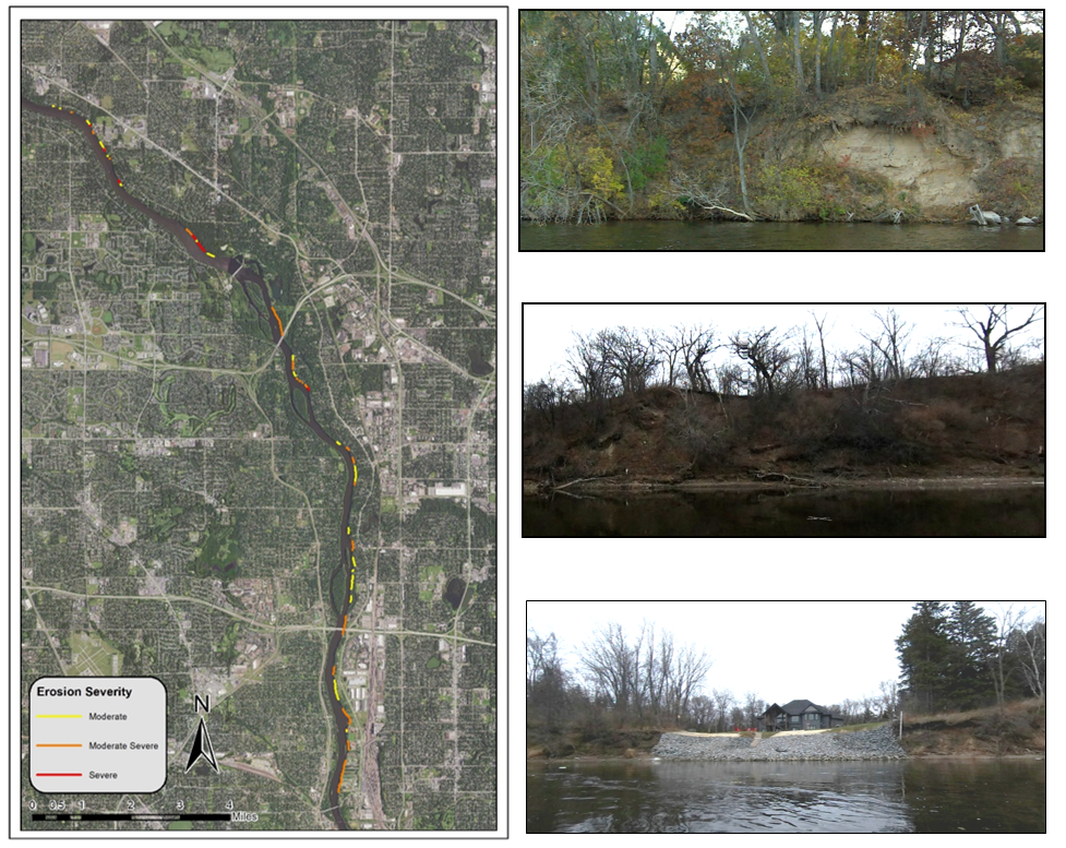
Mississippi River Erosion Inventory Highlights Bank Stabilization Needs, Gives Project Opportunities

The Mississippi River fulfills the water resource needs of millions of people and provides hydrological and habitat benefits of national significance. It is a powerful waterbody that has shaped the U.S. landscape for millions of years. Erosion is a naturally occurring process in flowing water systems such as the Mississippi River, but it can become exacerbated with increases in extreme weather events and in developed landscapes where stormwater drainage networks contribute to increased surface water volumes. Bank erosion can threaten adjacent urban and agricultural infrastructure and contributes to sediment and nutrient loading that impacts local water quality. Thus, riverbank stabilization practices that minimize erosion serve as mechanisms to combat these environmental challenges.

Using 360° photos captured from a watercraft on the Mississippi River, ACD identified the location and severity of eroded banks spanning from Coon Rapids to Fridley. Altogether, nearly 50 separate stretches of moderately to severely eroded banks were identified, collectively contributing to an estimated 8,517 tons of sediment inputs to the river each year. These stretches were present along both private and public properties ranging from dense residential areas to expansive county parks. A recommended stabilization approach and corresponding project cost estimate was applied to each eroded bank, thus providing cost: benefit scenarios for each potential stabilization project and facilitating the strategic pursuit of those which maximize environmental benefits.

These findings are detailed in a comprehensive report located here, which also includes further details on ACD's erosion inventory methodology, profile pages for each potential stabilization project, and information on a variety of riverbank stewardship and stabilization approaches. To view examples of completed stabilization projects identified through previous erosion inventories, view our interactive projects map here. For more information please contact Breanna Keith, This email address is being protected from spambots. You need JavaScript enabled to view it.763-434-2030 x160

  1196 Hits

Update - Riverbank Stabilization Project Construction in Mississippi River Community Park, Anoka

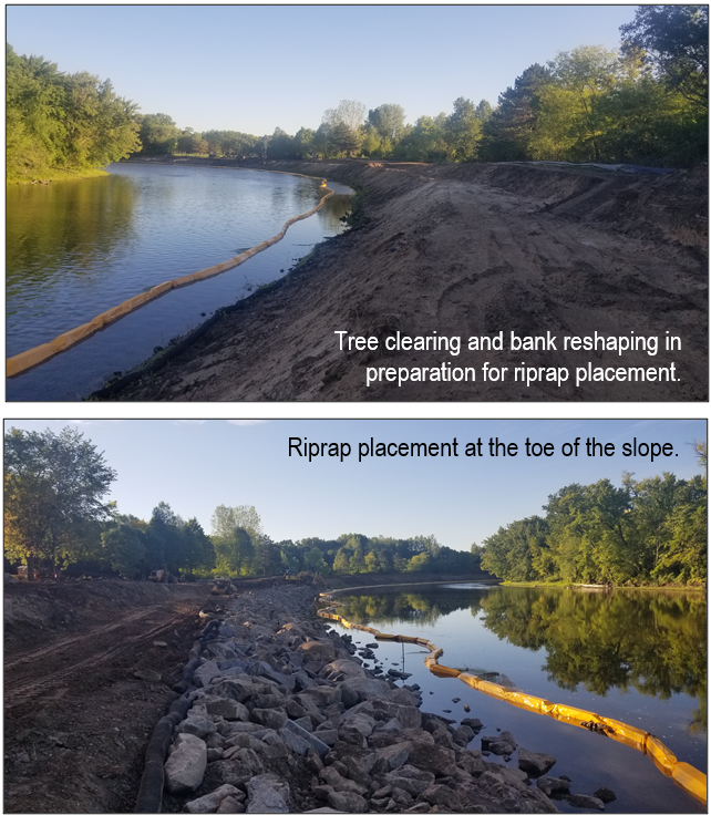
The riverbank stabilization project in Mississippi River Community Park is underway. Tree clearing, bank reshaping, and riprap installation have been the primary focus at this stage in the construction process.

Future work will include native seeding, erosion control blanket installation, and planting of native shrubs and trees.

The project is funded by a Clean Water Fund grant, a Watershed Based Funding grant, and match from the City of Anoka. Watch for more updates from ACD and the City of Anoka as the project progresses.

Read additional updates on our blog here and here.


UPDATE - October 2021

The riverbank stabilization project in Mississippi River Community Park is nearly complete. Tree clearing, bank reshaping, riprap installation, seeding, and erosion control blanket installation have all been completed. Planting of supplemental bare root shrubs, trees, and dormant live stakes will be completed by the end of November. The project stabilized approximately 1,500 linear feet of severely eroding riverbank.

  1004 Hits

Riverbank Stabilization Project Construction to Begin in Mississippi River Community Park

The riverbank stabilization project in Mississippi River Community Park will begin this month. The current schedule forecasts project completion in early October and includes the general process outlined below.

  • Clearing and grubbing – Existing vegetation will be removed within areas that will be regraded to achieve a stable slope.
  • Erosion control – Protections will be put in place to prevent exposed soil from leaving the site during construction.
  • Excavation and riprap placement – This is the primary step in the stabilization process. The steep slopes will be regraded, and riprap will be placed at the bottom of the slope within the zone of frequent water level fluctuation.
  • Planting – The regraded slope above the riprap will be stabilized with native vegetation. Seed mixes, plant plugs, shrubs, and trees will all be planted.

The project is funded by a Clean Water Fund grant, a Watershed Based Funding grant, and match from the City of Anoka. Watch for more updates from ACD and the City of Anoka as the project progresses.

  975 Hits

Mississippi Community Park Riverbank Stabilization Project Update

The project design and bid packet to stabilize approximately 1,500 linear feet of severely eroding riverbank within Mississippi River Community Park in Anoka were recently finalized. Contractor bids are due in mid-April, and project construction is anticipated this summer during periods of low water to maximize riverbank access. Below is an overview of the planned stabilization process.

  • A section of the walking trail will be removed during construction but will be replaced following stabilization of the riverbank.
  • Mature tree and vegetation removal will be required for project access and grading.
  • The nearly vertical bank will be graded to a stable slope.
  • Hard armoring with rock at the bottom of the slope will provide protection against high flows and ice. The rock will be placed over a layer of filter fabric for protection of the underlying soil.
  • Live cuttings and plant plugs will be planted just above the riprap for additional stability, nearshore wildlife habitat, and a more natural appearance.
  • The slope above the riprap will be vegetated with a native seed mix, shrubs, and trees.
  • Additional features of the stabilization include strategic placement of boulders to provide recreational access points for fishing and viewing the river as well as small outcroppings to create a diversity of flows and enhance aquatic habitat.

Eroding riverbanks contribute to the Mississippi River's sediment and turbidity impairments through direct loading of sediment and nutrients that degrade overall water quality as well as aquatic and nearshore habitat. Stabilization of actively eroding riverbanks is one of the most cost-effective practices to improve water quality because 100% of the sediment reaches the waterway.

The project is funded by a Clean Water Fund grant, a Watershed Based Funding grant, and match from the City of Anoka. Watch for more updates from ACD and the City of Anoka as the project progresses.


May 11th 2021 Update:

A total of 12 bids were received and reviewed by staff from the City of Anoka, Hakanson Anderson, and Anoka Conservation District. The bids were competitive and many were within the available budget. The City of Anoka City Council approved the bids and awarded the project to the low bidder at the May 3rd meeting. A pre-construction meeting will be held with the selected contractor within the next month to review all project elements and ensure the project gets off to a smooth start.

  1395 Hits

ACD Partnering with City of Anoka for Mississippi Riverbank Stabilization

Approximately 1,500 linear feet of eroding riverbank within Mississippi River Community Park in Anoka will be stabilized in 2021. The project is currently in the early stages of design and focuses on a stretch of severely eroding riverbank that was documented in an erosion inventory completed by ACD.

Eroding river banks contribute to the Mississippi River's sediment and turbidity impairments through direct loading of sediment and nutrients that degrade overall water quality as well as aquatic and nearshore habitat. Stabilization of actively eroding riverbanks is one of the most cost-effective practices to improve water quality because 100% of the sediment reaches the waterway.

Stabilization techniques will include bioengineering with native vegetation and a rock armored bottom of slope to stabilize the riverbank. The project will reduce pollutants by 529 tons of sediment and 847 pounds of phosphorus annually. Other benefits include aquatic life diversity and abundance, and improved drinking water quality because the project site is immediately upstream of drinking water intakes for the Twin Cities.

This project will also showcase river stewardship and enhance public recreation. Mississippi River Community Park and adjacent Anoka-owned King's Island include 1.7 miles of Mississippi River trail, 0.78 miles of riverfront, 0.91 miles of oxbow channel, pedestrian access to the island, sporting fields, public duck and deer hunting, and a fishing dock. This project will make over ¼ mile of unsafe riverbank more accessible, stable, and fishable for users. By naturalizing the riparian zone, this project complements the Mississippi River Corridor Critical Area rules.

The project is funded by a Clean Water Fund grant, a Watershed Based Funding grant, and match from the City of Anoka. Watch for more updates from ACD and the City of Anoka as the project progresses.

  1128 Hits

Mississippi Riverbank Stabilization Project Complete

The previously highlighted riverbank stabilization project on the Mississippi River in Ramsey has been completed. The residential property has 100 linear feet of riverbank that was nearly vertical and approximately 25' tall. Severe erosion was causing large portions of the bank to collapse and enter the river every year. The soil associated with those bank failures introduced significant volumes of sediment and nutrients into the river that contributed to water quality degradation. Stabilization of this severely eroding riverbank reduces annual sediment loading to the river by an estimated 224,000 lbs and total phosphorus loading by an estimated 112 lbs.

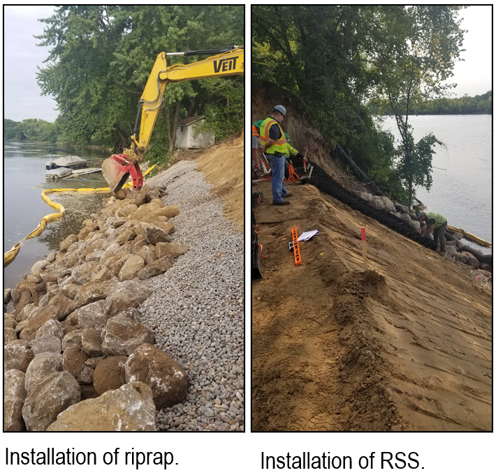
Project elements included clearing and grubbing of the few trees remaining on the steep slope, grading, riprap at the bottom of the slope, a reinforced soil slope (RSS) above the riprap to the top of the bank, native seed and plants, and erosion control blankets. The RSS consists of a honeycomb-like grid that is anchored to the slope and enables the finished slope to be steeper (e.g. 1.5 horizontal : 1 vertical), which maximizes the preservation of existing trees at the top of the slope.

Project funding is provided by a Clean Water Fund grant and landowner match.

  1556 Hits

Mississippi Riverbank Stabilization Construction Underway

Stabilization of a riverbank on the Mississippi River in Ramsey has begun. The residential property has 100 linear feet of riverbank that is nearly vertical and approximately 25' tall. Severe erosion was causing large portions of the bank to collapse and enter the river every year. The soil associated with those bank failures introduced significant volumes of sediment and nutrients into the river that contribute to water quality degradation. Stabilization of this severely eroding riverbank will reduce annual sediment loading to the river by an estimated 224,000 lbs and total phosphorus loading by an estimated 112 lbs.

Project elements include clearing and grubbing of the few trees remaining on the steep slope, grading, riprap at the bottom of the slope, a reinforced soil slope (RSS) above the riprap to the top of the bank, native seed and plants, and erosion control blankets. The RSS consists of a honeycomb-like grid that is anchored to the slope and enables the finished slope to be steeper (e.g. 1.5 horizontal : 1 vertical), which maximizes the preservation of existing trees at the top of the slope.

The project is on schedule to be completed by early October. Project funding is provided by a Clean Water Fund grant and landowner match.
  1530 Hits