Beavers Connecting Rivers to Floodplain Wetlands

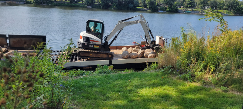
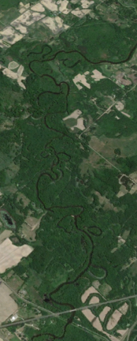
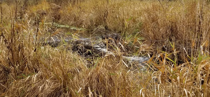
During a recent site visit to explore wetland restoration opportunities, ACD staff came across a fantastic example of beavers' "engineering" skills in action! A series of three beaver dams, located near the outfall of a Rum River tributary, were effectively slowing and spreading the stream's flow into the surrounding floodplain wetlands. Healthy connections between streams and their floodplains provide numerous water quality and habitat benefits, and in this case those benefits also extend to the Rum River immediately downstream.

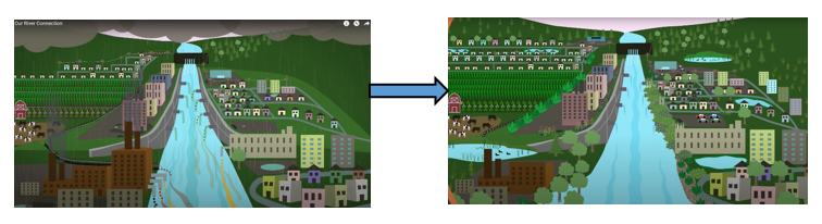
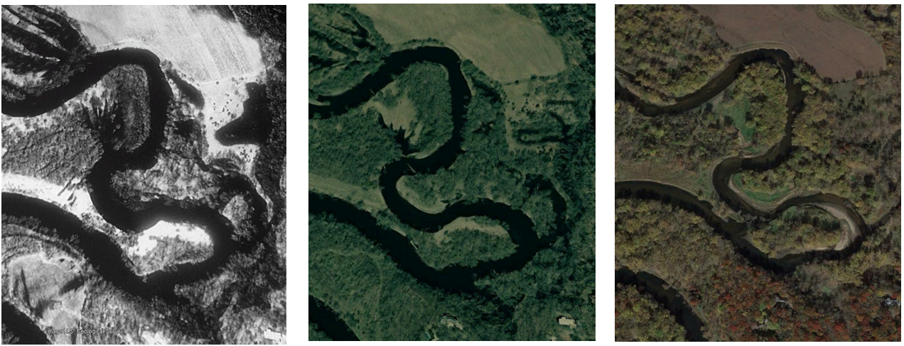
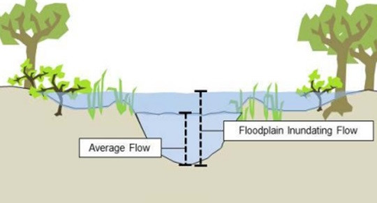
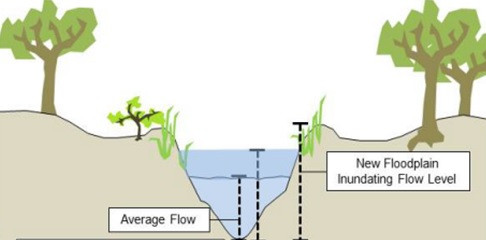
Many streams in modified landscapes take on excess water from artificial drainage features like ditches and storm pipes. Over time and especially during extreme precipitation events, these higher volumes of water often increase erosion within the stream, which can lead to the straightening and downward-cutting ("downcutting") of the stream channel and, as a result, the disconnection of the stream from its floodplain (see the figures below, produced by American Rivers). 

Connected Floodplain
Vertically Disconnected Floodplain

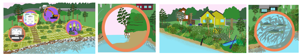
Floodplain reconnection efforts are an increasing priority amongst many conservation organizations, but they can be costly and complicated – particularly if development has occurred within the floodplain. However, in areas where streams have room to spill into their floodplains without causing damage, allowing and even promoting beaver activity can be a cost effective way to help restore riparian corridors. Learn more about the benefits of beavers in the articles below. 

- University of MN Study 

- King County, WA

- Riding Mountain National Park, Canada

For more information contact Breanna Keith, Water Resources Technician, at This email address is being protected from spambots. You need JavaScript enabled to view it. 

  707 Hits

“Our Riverbank Connection” Animated Video

Recent extreme flooding has highlighted the dynamic and powerful nature of flowing water. If you live on a river or even a smaller stream, you've likely witnessed these characteristics and their impacts firsthand. With flood waters receding, now is a great time to assess the condition of your riverbank and consider stewardship and stabilization approaches that will help protect your property and the water you live on. Fortunately, we've created a brand new resource to help guide you through this process – the "Our Riverbank Connection" animated video!

Living by a creek, stream, or river provides many benefits and a unique opportunity to support water quality and wildlife. It also comes with some challenges such as erosion, which can eat away at your land over time. In this video, you will learn how to create a river-friendly lawn and riverbank that also protects your property by reducing or repairing losses from erosion. Video topics include:

  • Recommended lawn care practices
  • Signs of erosion and factors that may make your bank more susceptible to it
  • Creating a well-vegetated bank
  • Bank stabilization approaches to address active erosion
  • Project planning and construction – what to expect

Watch "Our Riverbank Connection" here: https://www.youtube.com/watch?v=Et9wLuIrRuA

Want to learn more about streams and rivers and how you can help them, even if you don't live on their banks? Watch Part 1 of the "Our River" Installment – "Our River Connection" – here: https://www.youtube.com/watch?v=rdQEcmLyQJI 

  680 Hits

“Our River Connection” Animated Video: Understanding Rivers and the Ways We Impact Them

Rivers are essential resources and provide an immeasurable list of services that are critical for many ways of life throughout the world. Minnesota is home to many important river systems, such as the Mississippi River, that provide services which help sustain life and provide resources to help human economies thrive.

Minnesota's rivers endured decades of intensive impacts as the state industrialized, commonly used as a dumping grounds for untreated waste and modified extensively to make navigation easier. Our treatment of rivers has improved significantly in the years since, but human activity continues to impact them today. River systems are extremely complex in nature and many of the negative impacts caused by human activity go unrecognized or are misunderstood. Fortunately, there are many ways we can minimize our impacts and help restore our rivers to good health.

The Anoka Conservation District has proudly released a new animated video to help understand how rivers function and the role humans play in keeping them healthy. "Our River Connection" video brings you on a journey through a breadth of river topics, such as river formation, natural river behavior, current and historical human impacts, and actions we can take to protect them today. This video is suitable for a wide range of audiences, with narrative and visuals that are approachable and easy to digest. When you're done watching the video, you can take the companion quiz or explore the links in the video description to learn more. 

ACD Contact: Breanna Keith, This email address is being protected from spambots. You need JavaScript enabled to view it. 

  620 Hits

Stabilizing Riverbanks in Anoka

Construction is beginning on six streambank stabilization projects on the Rum and Mississippi Rivers in Anoka. These sites have had significant and accelerating erosion in recent years due to sustained high water and recreational watercraft. Most of the sites lie between two popular boat launches on the rivers.

Cumulatively, over 720 linear feet of eroding riverbank will be stabilized. The primary stabilization technique will be rock riprap on the lower portion of the slope, with a seeded and blanketed vegetative zone above the rock. This vegetative zone will be comprised of native species of grasses, sedges, and forbs to enhance the habitat and aesthetic value of the shorelines, while also providing deep root structure to anchor the soil in place above the rock. 

Mini excavator applying rock to a shoreline on the Mississippi River via barge

The projects will be done via barge from the water, a first for ACD-managed projects. Many of these sites had been on our inventories, but were not cost-effectively constructible in a typical fashion from land. With a contractor that can install the project from the water, concerns about equipment access between buildings and site restoration on individual properties are non-factors. Beyond stabilizing these six eroding shorelines, we are hopeful that this new construction technique opens up more potential streambank stabilization projects that would have otherwise not been possible from land.

Project updates will be provided as construction progresses. To see these and other streambank stabilizations projects already installed throughout Anoka County, please see the virtual project tour on ACD's website. 

  1180 Hits

The Oxbows of the Rum River

The Rum River in Isanti County


When allowed to wander freely, rivers flowing throughout a gently sloped landscape form a snakelike meandering path. This occurs as the fastest moving waters erode banks along the outer bends, and slower moving waters deposit sediment along the inner bends. Over many years, these processes cause the meanders to curve more intensely, causing the river to eventually loop back onto itself and cut a straight path through the narrow slice of land that remains. Now disconnected from the river, the C-shaped meander scar is called an oxbow.

To watch these processes in action, check out this video: Why Do Rivers Curve?

A quick glance at aerial imagery reveals numerous oxbow wetlands alongside the Rum River. They are rich in plant and animal life, serving as a "nursery" for fish, invertebrates, and amphibians in their early life stages while providing habitat for countless migratory bird species. These oxbows also improve water quality and reduce flooding by capturing water and the contaminants it carries following large storm events.

To learn more about the importance of oxbow wetlands and their utility in water resource management, read the Nature Conservancy's article on the topic here: What is an Oxbow? 

Aerial photos of a Rum River meander in Ramsey captured in 1991, 2003, and 2021 (left-right). Notice the increasingly thin sliver of land at the base of the curve, which eventually transitions to a river cut-through.
  1013 Hits

Isanti 5th Grade Conservation Day

On a cool and cloudy May morning, ACD participated in Isanti Conservation Day, an annual event designed to teach students about natural resource stewardship. Approximately 475 fifth graders were given a chance to get outside for a morning to learn about the natural world around them, and how to protect it, by rotating through stations scattered throughout Becklin Homestead Park. ACD collected a myriad of live aquatic invertebrates from local streams to give the students a hands-on way to learn about the unseen creatures that live in their favorite water bodies.

Each group examined trays containing wriggling nymphs of mayflies, damselflies, and dragonflies, case-building caddis fly larvae, freshwater shrimp, snails, and more. They excitedly gathered around their tables to observe the activity in their trays and tallied how many kinds of invertebrates they were able to identify from a provided list. This led to discussions on what the diversity and types of creatures found in the water could tell them about river health. Looking at their lists, students learned that they could make inferences about water quality based on the pollution tolerance of the invertebrates that they found. Each session was wrapped up by sharing ideas on actions and practices that they could take to protect the health of their local rivers. The event was engaging for the fifth graders and provided them with new perspectives on how people can learn about water quality.  

  821 Hits

Biomonitoring with Area High Schools

Each spring and fall, ACD staff teaches area high school students about collecting macroinvertebrates to track water quality in Anoka County streams. This lesson is educational and fun for students, while providing ACD with data to track water quality over time through the streams' biota. Biological organisms that can be used to track the health of the environment they live in are called biological indicators (or bioindicators for short).

Macroinvertebrates, the larval forms of many common insects, are a great biological indicator for stream health in particular. They also live in lakes and wetlands. Many people don't realize that common insects like dragonflies, mayflies, black flies, and many others spend the majority of their lives as larval forms in the water. These larvae have varying tolerance levels to pollution, meaning some need very clean water to survive, while others can survive in either clean or polluted water. By tracking the populations of these organisms over time, we can gauge changes in water quality by assessing population shifts and known tolerance levels. This provides a valuable supplemental dataset to water quality samples collected periodically. Because these organisms spend months to years in the water, they give a more comprehensive long term look at water quality than water samples collected at random times can alone. 

Anoka High School students sorting through Rum River samples for macroinvertebrates, May 2022

For the past 24 years, ACD has partnered with numerous schools and groups in Anoka County to collect macroinvertebrates. We currently partner with the Upper and Lower Rum River Watershed Management Organizations, the St. Francis American Legion, and the Rice Creek Watershed District to fund this monitoring with classes from four schools. Anoka High School and St. Francis High School classes monitor the Rum River near their schools, Totino-Grace High School classes monitor Rice Creek in Fridley, and the Forest Lake Area Learning Center monitors Clearwater Creek in Centerville. We also plan to take a new class from Blaine High School out in the fall of 2022 to monitor Coon Creek in Coon Rapids.

Over time, this program has taught thousands of Anoka County students about stream water quality, biological indicators, and work in the environmental sciences, all while getting them out of the classroom and into a stream. 

  922 Hits

Anoka County Lakes and River Photos on Google Street View

The Anoka Conservation District has been collecting photo inventories of lakes and rivers around Anoka County and uploading them to Google Street View. We use these photos to look for restoration and stabilization opportunities at eroded or degraded shorelines. You can also view these photos just like you can view streets on Google Maps! All of our photos are available to the public, and so far we have over 618k views! All you have to do to see the photos for yourself is:

1. Navigate to Google Maps in a web browser,

2. Zoom to the lake or river you are interested in (current list of completed inventories below),

3. Grab and drag the "Little Orange Man" in the bottom right of Google Maps to a blue circle or line in the lake or river,

4. And finally, you can pan photos as 360° orbs by clicking and dragging your mouse around. You can also advance around the lake or down the river by clicking the floating gray arrows that appear on the water to zoom to the next picture.

So far we have photos available on the following waterbodies:

  • Rum River
  • Mississippi River (south of Coon Rapids Dam)
  • Lake George
  • Coon Lake
  • Linwood Lake
  • Martin Lake
  • Typo Lake


We are planning to do more inventories in the coming years, so check back into Google Maps periodically, or continue to follow us for more updates!

  1882 Hits