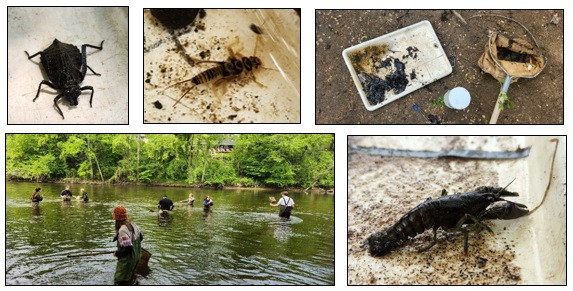
Each season, local high school students venture to a nearby river or stream, grab a dip net and pair of waders, and search for invertebrates (a mix of aquatic insects, crustaceans, bugs, snails, worms, and other critters lacking a backbone) living amongst the submerged rocks and vegetation. They bring their catch back to their partners on shore, who use guides to identify the invertebrates or preserve them for identification at a later date in the lab. In 2023, ACD staff led 560 high school students across 20 classes and 5 schools in these "biomonitoring" efforts. Besides being a great way to get some fresh air, students learned valuable lessons in aquatic ecology.
Individual aquatic invertebrates have different sensitivities to environmental disturbances such as contamination and habitat loss. Some, such as stonefly and mayfly nymphs, often have a strong negative reaction to disturbance, while others, such as leeches, midges, and aquatic worms, are usually more tolerant and able to persist through a variety of conditions. Understanding these tolerance thresholds across species is an efficient way to broadly assess the health of a waterbody. For example, a high quantity and/ or diversity of species including those considered "intolerant" (sensitive) is a likely indicator of healthy habitat and water quality, whereas the presence of only more "tolerant" species hints at poorer water quality and habitat. Biomonitoring data is often paired with other information, such as water quality or stream morphology data, to identify where aquatic impairments are present and management efforts should be pursued.
After the students have finished collecting and processing samples, ACD staff re-identifies them and summarizes the data in the annual Water Almanac. Through this, big-picture trends in invertebrate communities (and stream health, by extension) can be explored across time. For more information contact Breanna Keith, Water Resource Technician, at
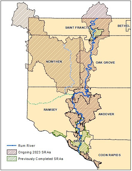
Stormwater runoff from human-modified landscapes is a source of excess water and pollutants that can significantly impact rivers, lakes, and wetlands on the receiving end. However, not all drainage areas are created equally; rural landscapes with abundant agriculture and artificial drainage features, or urban areas with infrastructure predating stormwater treatment regulations, are often the most impactful. Areas draining to a priority waterbody are targeted for Subwatershed and Stormwater Retrofit Analyses (SRAs and SWAs). In these analyses, we study how runoff is moving through the landscape, strategically place various Best Management Practices (BMP's), and estimate their anticipated water quality benefits and installation costs. These findings are then summarized into a report which can be referenced by ACD staff and local natural resource managers to pursue the most cost effective projects.
ACD has completed several SRA/ SWA reports, but current efforts are focused on areas draining to the Rum and Mississippi rivers. Projects sited in these areas include rain gardens, subsurface treatment structures, enhanced street sweeping, wetland restorations, soil health practices (cover crops, no- till farming, etc.), and targeted agricultural practices (grassed waterways, riparian buffer enhancements, control basins, etc.). Altogether, approximately 150 urban BMPs and over 300 rural BMPs have been sited, and their associated SRA/ SWA reports will be released in the coming months.
For more information contact Breanna Keith, Water Resources Technician, at
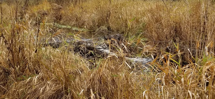
During a recent site visit to explore wetland restoration opportunities, ACD staff came across a fantastic example of beavers' "engineering" skills in action! A series of three beaver dams, located near the outfall of a Rum River tributary, were effectively slowing and spreading the stream's flow into the surrounding floodplain wetlands. Healthy connections between streams and their floodplains provide numerous water quality and habitat benefits, and in this case those benefits also extend to the Rum River immediately downstream.
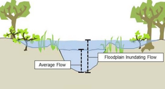
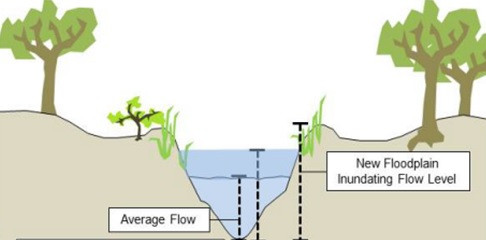
Many streams in modified landscapes take on excess water from artificial drainage features like ditches and storm pipes. Over time and especially during extreme precipitation events, these higher volumes of water often increase erosion within the stream, which can lead to the straightening and downward-cutting ("downcutting") of the stream channel and, as a result, the disconnection of the stream from its floodplain (see the figures below, produced by American Rivers).
Floodplain reconnection efforts are an increasing priority amongst many conservation organizations, but they can be costly and complicated – particularly if development has occurred within the floodplain. However, in areas where streams have room to spill into their floodplains without causing damage, allowing and even promoting beaver activity can be a cost effective way to help restore riparian corridors. Learn more about the benefits of beavers in the articles below.
- Riding Mountain National Park, Canada
For more information contact Breanna Keith, Water Resources Technician, at
Minnesota is rich in wetlands which provide numerous benefits such as flood mitigation, groundwater recharge, water quality improvement, recreation, and high-quality habitat for a wide variety of fish and wildlife species. However, many wetlands exist in a degraded state due to decades of human disturbances such as drainage and filling to increase usable land for agriculture and urban development.
Recognizing their importance, many federal, state, and local agencies have developed programs to provide technical expertise and funding for wetland restoration projects. The goal of wetland restoration is to return a wetland to its natural functions, and the nature of each project depends on the wetland's unique location, hydrology, soils, vegetation, and impacts (historic and current).
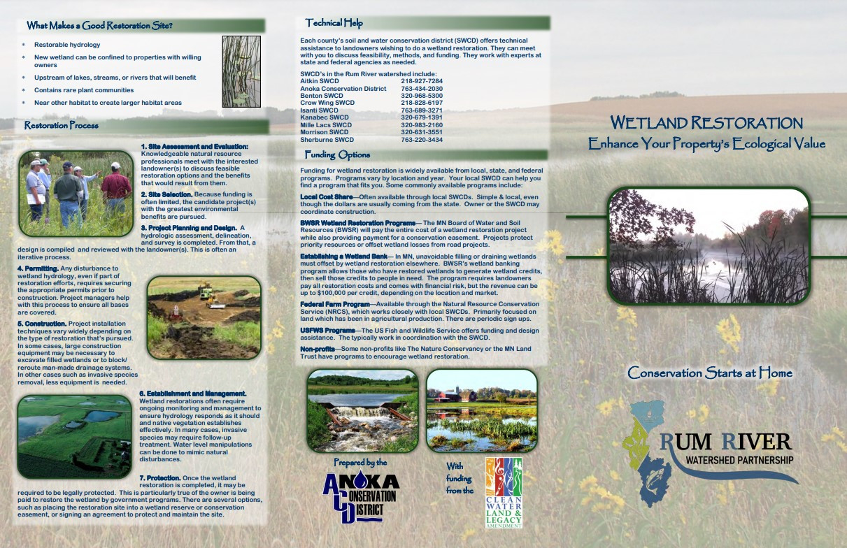
Restoring wetlands on your property adds to its ecological value and can often be financially beneficial. Understanding your options can be complicated, which is why ACD – on behalf of, and with funding from, the Rum River Watershed Partnership – created a new wetland restoration brochure. In it, you will find information on benefits, approaches, processes, and funding options common for wetland restoration projects. Click here to access the brochure below.
Anoka County Residents: ACD currently has funding to support wetland restorations benefitting the Rum River! If you live near the Rum River, believe that you have impacted wetlands on your property, and are interested in restoring them, please contact Breanna Keith, Water Resources Technician, at

